|
Just a few miles from the ramp at mile marker 15 of the GIWW, I come to the beginning of the Barataria Waterway. The Barataria runs south through the heart of bayou country for 35 miles where it ends at Grand Isle and the actual Gulf coast. I decide that since the winds are light now would be a good time to find what it has to offer. I am concerned with the wind because I note on the GPS that there are several large open areas of lakes and bays that would allow seas to build. Not that Therapy can’t handle it as she has proven very sea worthy. But the ride does get rough if I try to maintain speed and I have found my body isn’t nearly as durable as the boat. I decide to make the run to the Gulf and turn south.
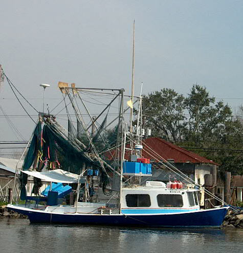
The number of boats lining the shore immediately impresses me. Many have a very similar hull design that is unfamiliar to me. They are quite beamy yet have very low freeboards. Most sport a very forward enclosed pilothouse that is usually angular or boxy. At the transom there is a full width fantail that protrudes aft several feet. It obviously is a case of form following function. In addition there are the large rigging for nets. I assume they are for shrimping.
On shore behind these boats are homes that obviously represent a wide range of incomes. Honestly, this somewhat puzzles me. The more modest homes I understand and guess that the owner earns a living with the boat. But some of the homes are very nice. I may be completely incorrect but I would be surprised if working one of these boats professionally would produce the income level necessary to support some of the homes where they are docked. Yet, if not used to earn a living, I wouldn’t think that many owners of these very nice homes would have this type and size (many looked to be in the 30’ to 40’ range) for purely sport use. I have never heard of “sport shrimping”. Perhaps they use them for supplemental income. I haven’t a clue. If someone reading this has the answer I would be interested. (QUESTION ANSWERED! - Click Here)
I was now again on my way southward. The area continued to be populated with moored boats, homes and an occasion business. But now and then I was seeing “No Wake” signs and this started to make me nervous. I have found it is not unusual to see these posted on private property and for me this is always somewhat of a dilemma. I completely understand the landowners desire to protect their property and/or floating watercraft from damage. Large wakes can wreak havoc and harm. But at the same time if everyone is allowed to “declare” their domain as No Wake many rivers would become that from start to finish. In a way it reminds me of someone that builds a new home next to an interstate highway because they like the convenience but then complain that there is too much noise. They demand like either slower speed limits or sound barriers – naturally, all at the public’s expense. Another example we see a lot in the Midwest are people that build homes on a river's flood plane and then are aghast when the water rises and flows in.
It seemed very arbitrary to me. As I was leaving they commented that if I remained at No Wake speed I would be the only one out there that does…………..
Now more confused than before I stopped I continued on south off plane. I was by far the smallest craft around and don’t make a wake large enough to hardly rock much less damage most of the boats moored along the shore. A few minutes go by and I was passed by 20’ open fishing boat running normal cruising speed. A few minutes more and a center console passed on plane going the opposite direction. Well, I guess they were right at Joe’s. I advanced the throttle and got up on top the water. I paid attention to what few people there were working on their docked boats and none offered the middle finger salute (how wake violators are usually greeted in the Midwest!) or even took time to look up. Either it wasn’t truly a No Wake area or I was just considered more and an annoyance than a problem.
|
 Since
I had no expectations of covering epic amounts of river on this trip I
slept in until about 8 am. Upon climbing out of the berth I
found the day to be thinly overcast with light wind. The real
delight was the 55-degree temperature – a world away from the 20-degree
mornings I had abandon far to the north. I slid Therapy off
the trailer and secured the truck under a street light on the
gravel-covered parking lot. Finally – on the water.
With the Honda purring I set a course westward.
Since
I had no expectations of covering epic amounts of river on this trip I
slept in until about 8 am. Upon climbing out of the berth I
found the day to be thinly overcast with light wind. The real
delight was the 55-degree temperature – a world away from the 20-degree
mornings I had abandon far to the north. I slid Therapy off
the trailer and secured the truck under a street light on the
gravel-covered parking lot. Finally – on the water.
With the Honda purring I set a course westward.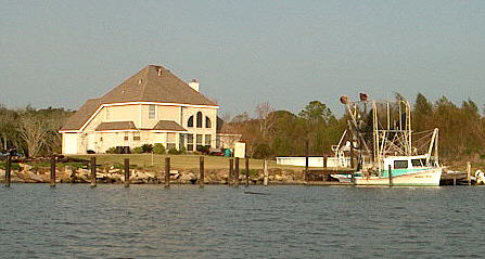 At
Barataria mile marker "1" a low swing bridge spans the
waterway. As I approach I realize I didn’t know what radio
channel to use to hail them or even the name of the bridge (remember -
no chart). My experience has been that trying CH 16 often yields no
response. My best guess was CH 13 or 14. I was
reaching for the radio when I realized there just might be room under
the starboard side of the fixed portion for me to squeeze
under. I lowered my antenna and approached slowly.
Sure enough I was able to clear the metal structure by about six inches.
At
Barataria mile marker "1" a low swing bridge spans the
waterway. As I approach I realize I didn’t know what radio
channel to use to hail them or even the name of the bridge (remember -
no chart). My experience has been that trying CH 16 often yields no
response. My best guess was CH 13 or 14. I was
reaching for the radio when I realized there just might be room under
the starboard side of the fixed portion for me to squeeze
under. I lowered my antenna and approached slowly.
Sure enough I was able to clear the metal structure by about six inches.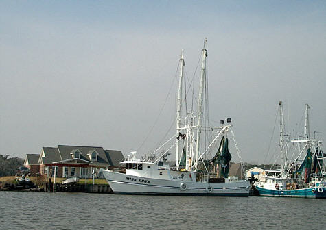 But
at the same time I want to be a conscientious boater. If this
is indeed an “official” no wake area I want to comply. The
thing that has me wondering is that often the private signs have a
“homemade” look but some of these signs appeared official. I
was passing Joe’s Landing, a marina at the 5 mm and decided to stop in
and ask. (There are numerous marinas along the Barataria.)
They informed me that some of the signs were indeed private and had no
real authority. Others, they said were questionable, but at
any rate were intended for larger craft making large wakes.
They added that a boat my size was not a problem and I need not worry
about it.
But
at the same time I want to be a conscientious boater. If this
is indeed an “official” no wake area I want to comply. The
thing that has me wondering is that often the private signs have a
“homemade” look but some of these signs appeared official. I
was passing Joe’s Landing, a marina at the 5 mm and decided to stop in
and ask. (There are numerous marinas along the Barataria.)
They informed me that some of the signs were indeed private and had no
real authority. Others, they said were questionable, but at
any rate were intended for larger craft making large wakes.
They added that a boat my size was not a problem and I need not worry
about it.