|
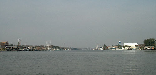
But still I had a need. Horace Greeley said, “ Go west, young man” but for this middle age guy south seemed to offer the best respite from the cold and high water levels. The Intracoastal Waterway (ICW) around New Orleans has interested me for some time. Heading west from the Big Easy the Gulf Intracoastal Waterway West (GIWW) offers numerous access routes to the actual gulf but the majority of the passage is on river like canals that are often 30+ miles from the coast.This would provide the sheltered water that I prefer while still allowing the option of a run to the big water if conditions are favorable.
One afternoon a close look at my work calendar surprised me with an open slot. The only problem was if I were to go it must be right then. I mean the next day! Other than that it would be at least 45 days before I “might” be able to work it out. So at 4:00 pm I decided I would leave the next morning. This would leave little time for the reasonably thorough preparation I normally try to accomplish. Not ideal since it helps reduce the number of minor annoyances that always seem to find their way onboard but sometimes you have to do what you have to do!
The first and most prominent problem is the lack of charts. As I have stated many times before it always helps reduce stress if I have the necessary charts - and less stress is what this is all about. My GPS does a great job but when running in unfamiliar water it is still not total substitution for the paper charts. Scrolling back and forth on GPS’s 5” screen can be annoying. Zooming out can cause a loss of detail that is sometimes required when trying to plot a course. On the other hand using both the GPS and chart offers an abundance of information that I can easily compile into an accurate and safe passage.
But on this trip I won’t have that advantage. I console myself with the thought that I have decided not to try to cover an abundance of miles. Just go down there and knock around while enjoying time on the water. A quick check of my computer mapping applications showed that the area I had in mind is about 680 road miles! That’s a long drive. I will burn a day down and a day back. But that’s OK, as I still will have four days on the water.
So I leave work at 5:00 pm and I run to do some shopping for provisions. Next, I get home and pull out my checklist of items needed for a trip. (Over time I have compiled a list of everything I need to take. This is a big help in making sure I don’t get to the ramp only to find I have forgotten something!) Next morning Therapy is hauled out of the shed and loaded. By 10:30 I pull out of the driveway for the long journey south.
A little more than 12 hours later and in the dark I arrive in the vicinity of the park. I say vicinity because I can’t find it! I drive back and forth on the narrow roads peering into the shadows of the headlights trying to find the sign to point the way. Nothing…… There were some homes in the area but because of the late hour I hesitated to knock on anyone’s door and ask directions – plus I’m a GUY, we don’t ask directions! I keep wandering.
I decided to cross a bridge and try the other side of the canal. Maybe I misunderstood the directions. No luck. But then I came upon a manufacturing plant of some type and noticed a guard in a small building. I swallowed my pride and stop and ask about the ramp. He told me it is directly across the river and offered directions. Listening to his instructions I realized I had been right by the park access road. Puzzled, I asked him about the “big” sign. He replied, “What sign?”
A few minutes later I pulled into the parking lot. It was a somewhat remote area but I noticed a police car nearby sitting with the lights out. At first I thought it was just parked but then the faint glow of a cigarette betrays the darkness and I realized the officer is just relaxing while watching the water silently flow by. I climbed out of the truck and into Therapy’s berth bedding down for the night. It had been a long drive and sleep comes easily.
|
 The winter seemed to be dragging on.
Come late January of 2005 the urge to launch Therapy on another river
voyage was growing unbearable. But where to go? It’s January
for heavens sake and cold everywhere around here. Not to
mention the Midwest (and a lot of the rest of the country) have had
record winter rainfall causing many rivers to be at flood stage.
The winter seemed to be dragging on.
Come late January of 2005 the urge to launch Therapy on another river
voyage was growing unbearable. But where to go? It’s January
for heavens sake and cold everywhere around here. Not to
mention the Midwest (and a lot of the rest of the country) have had
record winter rainfall causing many rivers to be at flood stage. The
next item needed is to locate a ramp I can use to drop in and then
leave the truck and trailer parked. Once again I use Quimby’s
Cruising Guide to find a marina in the area. I
call and ask for advice and directions and
am informed about a small park at Crown Pointe, LA with a ramp
and large parking lot. They state there is a big
sign on the main road noting the turnoff to the park. As
always, I ask about possible problems with security in the area since
the truck will be setting there several days. They reply it will be
fine.
The
next item needed is to locate a ramp I can use to drop in and then
leave the truck and trailer parked. Once again I use Quimby’s
Cruising Guide to find a marina in the area. I
call and ask for advice and directions and
am informed about a small park at Crown Pointe, LA with a ramp
and large parking lot. They state there is a big
sign on the main road noting the turnoff to the park. As
always, I ask about possible problems with security in the area since
the truck will be setting there several days. They reply it will be
fine.