|
At this point there was only one choice and it involved getting wet. When boating I usually wear cargo pants with zip off legs. These are handy as they go from pants to shorts with ease. Off with the shoes, socks and pants legs and over the side I go. Its 52 degrees outside and the water temperature is identical so it is really not to bad – as long as it stays below the knees. With my weight removed Therapy is now buoyant enough to float so I walk it about 100 feet to where it is deep enough for the Honda to drink properly. Finally I am on the water. As I make my way the 7 miles to the lock I find the fog patchy but acceptable. The biggest problem is that the windshield keeps getting covered with mist and I have to reach around ad wipe it off now and then. As I get closer to the lock the fog suddenly thickens. I pass along side two barges sitting dead in the water. I too decide to slow it down. I pass the front of the second barge and know the lock is up there somewhere but I sure can’t see it. I drop off plane and ease my way forward. Slowly it appears from the mist. I call the lockmaster and he tells me I can enter the small chamber as soon he opens the miter gate. As I enter I hear him talking to the tow captains. They want to enter the main chamber but can’t see the front of their barges much less the lock so they are sitting and waiting for the fog to lift. I lock on through and head down the canal towards the Missouri. Visibility is fairly good at first and then goes completely sour. In fact, it suddenly get so thick I loose sight of both shorelines of the narrow canal. I jerk back the throttle and ease my way to the starboard watching my dept sounder (I did take time to set the bottom alarm this time). I find that I have to get within 15 ft of the riprap-covered shore before I can see it and then I can only see it out the side window. Out the windshield I can see nothing but gray. This is the thickest fog I have ever experienced. I continue on very slowly. My only positive thought was that any tows would be sitting still so at least I won’t get run over. The fog thins just a little and I suddenly I see movement of some kind out the windshield. I cut hard to the port away from the shore. As I pass by I find two young men in about a 16’ aluminum jonboat rowing towards the lock. They have two mountain bicycles mounted on a rank on the transom and a small makeshift mast and sail standing in the front. I note some angled plywood backrests fabricated on the two flat seats. I wave as I go by. It really wasn’t extremely close but certainly close enough to get my heart pounding. After I calmed down I wished I had stopped and asked about their journey. Obviously they were making some type of a run but I am curious as to the details. I really didn’t see a lot of gear and it is mid November. In 3 or 4 days the temperatures could easily be below freezing at night. But there is no way I am turning around and going back in this fog just to satisfy my curiosity. Fortunately, as I reach the mouth of the Missouri things have much improved and I have no problems entering. As advertised I find the current strong and rock dikes everywhere. I have the chart out and am following closely as all the dikes are indicated. Also, it shows the suggested sailing line so I can tell where I should be relative to the shorelines. A few times the fog rolls in again and I have to drop off plane for a while. The dikes make me nervous when I can’t see both shores. But I take it easy and concentrate on keeping up with the chart.
The Missouri bends back and forth as it snakes its way across the rural countryside. At mile marker 27 I approach the first town – St. Charles, MO. I have been there many times but this is my first view from this vantage point. Frontier Park is located along the waterfront but unfortunately there is no easy access from the river. Also, a little farther downstream is the Ameristar Casino one of the two riverboat gambling establishments in the area. Leaving St. Charles I pass under the Interstate 70 (Blanchet Bridge) and at about mile marker 31 I pass the Harrah’s St. Louis Casino on the port side. This is our famous “boat in a moat.” When gambling was first established in Missouri the idea was to limit it to riverboats. To qualify the boats had to be on the river and be capable of cruising at regular intervals while the patrons were gambling.
As the miles flowed by the fog completely dissipated as the sun burned through. The wind stayed calm and although the water was smooth I couldn’t call it glass smooth. The current was always apparent as the water swirled and formed small whirlpools almost everywhere I looked. The Mississippi does this in places but not nearly as pronounced as the Missouri. In fact every once in a while I would hit a pothole! Suddenly the boat would just bounce up and down a little and I would hear a dull thud. The first time I experienced it I thought I had hit something submerged but I just didn’t feel or sound right. After a few more times I realized it was just the turbulence in the swirling water that was thumping the hull. I had never run into this before. Around the 46 MM I noticed people walking and bicycling along the river even though it was a completely rural location. I looked closer at the chart and realized that they were on the Katy Trail. Although I have never had the pleasure to investigate the trail, I do know a little about it. It is touted as America’s the longest Rails-to-Trails project as it is situated on a former railroad bed that was abandon in 1986 by the Missouri-Kansas-Texas (MKT) Railroad (better known as the Katy). It spans 200 miles from East of St. Charles, MO to west of Sedalia, MO. For about 150 miles of its length it follows nearby the Missouri River’s northern shore before crossing at Boonville and heading a little more south. Because it is a converted railroad bed it is fairly flat which makes hiking and bicycling pleasant as it passes through some of Missouri's most scenic bottomlands, by limestone bluffs and through numerous small towns. Today is an absolutely marvelous day and many people seem to be taking advantage of the trail.
|
 I walked down the ramp,
crawled over the bow and into the cabin. I fired up the Honda,
backed up a little and current swung the bow around as I started to ease
her forward. I was trimmed very high but suddenly felt the lower
unit drag. I trimmed as high as I could and still feed the outboard
water but went nowhere. I could tell by the feel I was on
sand. I shut it down, trimmed all the way up and pulled my trusty
paddle out (the first time I had ever used it) and tried to push Therapy
off. I made a little headway but then hung again. I messed
with it for about 5 minutes before I finally decided it was hopeless – I
was sitting firmly on the bottom.
I walked down the ramp,
crawled over the bow and into the cabin. I fired up the Honda,
backed up a little and current swung the bow around as I started to ease
her forward. I was trimmed very high but suddenly felt the lower
unit drag. I trimmed as high as I could and still feed the outboard
water but went nowhere. I could tell by the feel I was on
sand. I shut it down, trimmed all the way up and pulled my trusty
paddle out (the first time I had ever used it) and tried to push Therapy
off. I made a little headway but then hung again. I messed
with it for about 5 minutes before I finally decided it was hopeless – I
was sitting firmly on the bottom.
 I continue upstream and
things are getting better. I slow now and then to snap a picture or
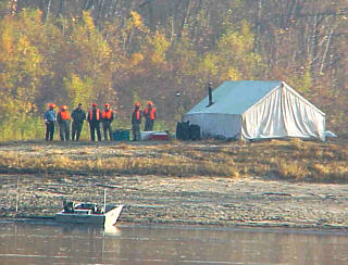
two of interesting structures. Also, deer season is open this
weekend and there are quite a few hunters camping on sandbars along the
way. I see a few jonboats but they are all pulled up along the
shore. The water is smooth as there isn’t a breath of wind
blowing. The Honda hums away and by the difference between the
speedometer and the GPS I figure the current is about 3 or maybe 4
mph.
I continue upstream and
things are getting better. I slow now and then to snap a picture or
two of interesting structures. Also, deer season is open this
weekend and there are quite a few hunters camping on sandbars along the
way. I see a few jonboats but they are all pulled up along the
shore. The water is smooth as there isn’t a breath of wind
blowing. The Honda hums away and by the difference between the
speedometer and the GPS I figure the current is about 3 or maybe 4
mph.
 It didn’t take long for
someone to come up with the idea digging a hole in the middle of a nearby
field and setting a series of barges in it and building a casino on top of
them. Then a narrow ditch was cut to the river and the water flowed
in to appear to float the land lock “riverboat”. The public dubbed
it a “Boat in a Moat.” They actually had scheduled “cruises” where
the entryways would be closed so patrons could only “board or disembark”
at posted intervals. When the gates were closed they were officially
“cruising” the river! It was hilarious but effectively circumvented
the law and established for all practical purposes a land-based
casino. So much for good intentions!
It didn’t take long for
someone to come up with the idea digging a hole in the middle of a nearby
field and setting a series of barges in it and building a casino on top of
them. Then a narrow ditch was cut to the river and the water flowed
in to appear to float the land lock “riverboat”. The public dubbed
it a “Boat in a Moat.” They actually had scheduled “cruises” where
the entryways would be closed so patrons could only “board or disembark”
at posted intervals. When the gates were closed they were officially
“cruising” the river! It was hilarious but effectively circumvented
the law and established for all practical purposes a land-based
casino. So much for good intentions!