|
From Pickwick to Florida
Since I had already traveled the Tennessee River from end to end I decided to tow Therapy down to Pickwick Lake which is part of the Tennessee River and drop in at the State park . From that point the mouth of the Tennessee-Tombigbee waterway (Tenn-Tom) is about an eight mile run along a scenic section of the lake. The plan was to follow the Tenn-Tom to its end at Mobile Bay (Mobile, AL) and there catch the Intarcoastal Waterway and continue on to Destin, FL. My friend has a home on the water in Destin right on the ICW. This would involve passage though twelve locks and since this was a round trip for me I would see twenty four lockages! As our departure date grew close everything looked great except one little problem - well actually two little problems - Isadore and Lilly. When making plans for trips in the past the weather wasn't a huge concern. Sure wind and rain could make it a little less enjoyable but storms and bad weather in the Midwest are usually measured in hours not days. And the twisting turning nature of rivers usually provides shelter from the wind and waves every few miles. But now for the first time I had to think about hurricanes. Isdore was scheduled to come ashore a few days before we left and didn't look to be a problem. But another storm was brewing and looked to have potential as another hurricane. We watched the weather closely in the days leading up to our trip and it looked like we could probably make the run between the storms. So with an eye on the weather we set out to run to Destin. One other minor problem did crop up the night before we left. I was watching local weather forecast and in our area they were predicting cloudy conditions as a result of Isadore. They also made mention that the aftermath of the hurricane had dropped 6 to 8 inches of rain in Tennessee the day before. The sky was to be clear there by the time we departed BUT rivers all over the state were flooding...........
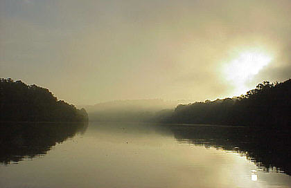
We reached Pickwick State Park and slid Therapy off the trailer about 2:30 PM. The sun was shining; winds were light and the temperatures in the upper 70's - just perfect! We made our way up the Tennessee to the 215 mile marker where an unassuming channel delivers us onto the Tenn-Tom. As we snaked our way through the somewhat confusing channels we pass Grand Harbor Marina. It is a first class facility with new floating slips and high-rise lodging. There were buoys to mark the path so staying on course really wasn't a problem. After about six miles we reached the first "canal" section and all concerns of navigation are put to rest - your either going or coming. This may be a good point to give a brief description of the Tennessee - Tombigbee Waterway. Rather than being the normal channelized river the Tenn-Tom is actually a series of waterways connected by canals. As rivers go this one is brand new. The Corps of Engineers began the project in 1972 and it opened for traffic in 1985. The goal was to shorten and improve the trip from the Midwest south. Until that point the Mississippi River was the only choice but its high current, hairpin turns and lack of services and anchorages make it a trying trip - especially for pleasure craft making the voyage to Florida. The Tenn-Tom not only makes it a much more pleasant run but shortens the length from Cairo, IL (confluence of Mississippi and Ohio Rivers) by about 250 miles. Since its opening many marinas have come to life along it shores and finding a nice place to anchor out is rarely a problem. It should also be pointed out that although the entire route from Pickwick Lake to Mobile Bay is often called the Tenn-Tom it is somewhat in error. The Tennessee-Tombigbee Waterway runs from Pickwick to the junction of the Black Warrior River at Demopolis, AL. From that point south it is the "Lower Black Warrior - Tombigbee Waterway". In order to have river charts of the entire route a chart for each of these waterways need to be obtained from the Corps of Engineers. But Tenn-Tom is much easier to say than "Tennessee-Tombigbee Waterway and Lower Black Warrior - Tombigbee Waterway". As a result, it is used by most to describe the route and for the sake of brevity I will do the same. We were now running down our first stretch of canal and the chart showed to be about 22 miles long. The shorelines are rock covered up fairly high between the 250 to 300 feet wide channel. Also we are noticeably lower in the canal than the surrounding landscape. I was at first surprised by the lack of floating debris. On the driving trip down we had noticed several flooded streams and the water level here seemed to be about four feet higher than normal. The water was a little muddy but no junk floating.
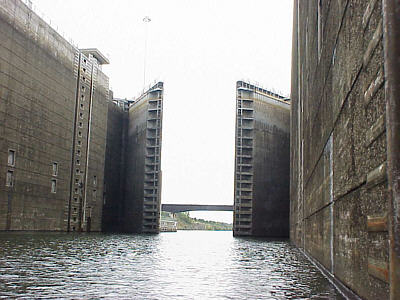
What appears to be happening is not only do they control erosion but serve to "strain" the inflow of all larger debris. Although large volumes of water were still entering the canal through some of these passageways it was still relatively clear of flotsam. About forty miles down the Tenn-Tom at the 411 mile marker we come to Whitten Lock & Dam which is the first of the twelve locks. I have my Quimby's Cruising Guide along as usual but I noticed that in the 2002 edition they have omitted the normal "lift" found at each lock along the Tenn-Tom (these were in the 2001 edition). Not knowing what to expect we called the lockmaster on the radio and were allowed to enter the 600 x 110 chamber. This is the standard size for all the locks along the waterway. We tied to the floating pins (again standard in all the Tenn-Tom locks) and began our descent to the river below. It is worth mentioning that lockage procedure on the Tenn-Tom is again different than what I have encountered before. First, channel 16 should always be used for initial contact. Although most run on the normal channel 12 or 14 some are on odd channels such as 18 or 74. Just use 16 and they will indicate what channel to use for further communication (for some reason my radio would not work on 18 and we had to use 16 when at that lock). All the lockmasters instructed us to have the person handling the mooring lines to have on a life jacket (although this is required by law many locks are lax in enforcement). It was also requested that we inform him when we were secure on the pin and usually they would not begin to close the miter gates until we acknowledge we were secure. Also, several of the locks have very high floating pins with no provisions for smaller boats. In several cases we had to stand on gunnels and reach up as much as possible to attach the line.
We are now sitting in Therapy slowly receding with the water level in the chamber. We kept going lower - and lower - and lower. Being my friend's first passage though a lock I could see the amazement on his face as we dropped 80 feet before the huge lower miter gates slowly swung open. This is the second deepest lock I have passed through with only Wilson on the Tennessee River being higher at 92 feet. Interestingly, Wilson is only about 35 miles away. Our southward journey continues and we find
that along this stretch
of the Tenn-Tom the locks are VERY closely spaced. Only six
miles
from Whitten we encounter Montgomery Lock and pass through making about
a 25 feet drop. And then just eight miles farther and we enter Rankin
Lock
and repeat about the same descent.
|
 As
the fall of 2002 approached I decided I wanted to make one more long
trip
before the frigid months of Southern Illinois set in. By
chance a
friend from my area whom had retired a year ago and moved to Destin, FL
was coming up for a visit. I decided rather than him driving
back
to Florida with his wife (boring!) we would load up Therapy and I would
take him home by water.
As
the fall of 2002 approached I decided I wanted to make one more long
trip
before the frigid months of Southern Illinois set in. By
chance a
friend from my area whom had retired a year ago and moved to Destin, FL
was coming up for a visit. I decided rather than him driving
back
to Florida with his wife (boring!) we would load up Therapy and I would
take him home by water.
 I
logged on to the Internet and started checking river gauge reports
along
our route. In some places the water had been up more than 10
feet
above normal pool but was it dropping everywhere. On the
positive
side the current would be high and actually help on our southward
journey.
My hope was with any luck it would recede by the time I returned so I
wouldn't
have to fight a more upward battle. But my biggest concern
was that
high water levels would sweep the shores clean of debris and dump it
all
in the waterway. I really hated to think of running 450 miles
on
the Tenn-Tom dodging logs!
I
logged on to the Internet and started checking river gauge reports
along
our route. In some places the water had been up more than 10
feet
above normal pool but was it dropping everywhere. On the
positive
side the current would be high and actually help on our southward
journey.
My hope was with any luck it would recede by the time I returned so I
wouldn't
have to fight a more upward battle. But my biggest concern
was that
high water levels would sweep the shores clean of debris and dump it
all
in the waterway. I really hated to think of running 450 miles
on
the Tenn-Tom dodging logs!
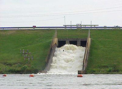
 After
a few miles I realized why this was happening. Because the
surrounding
land was higher by about 30 feet special care had been taken to allow
runoff
to enter the canal without causing erosion to the banks. The
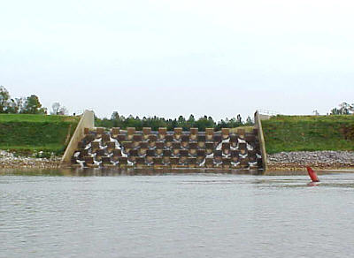
two
methods used were what I call "slots" and "weir" type
spillways.
The slots were used for smaller creeks and were concrete troughs about
two feet wide and eight feet deep following the slope of the
banks.
The larger streams were fitted with spillways divided by
weirs. They
are somewhat hard to describe but the photo to the right should clear
that
up.
After
a few miles I realized why this was happening. Because the
surrounding
land was higher by about 30 feet special care had been taken to allow
runoff
to enter the canal without causing erosion to the banks. The
two
methods used were what I call "slots" and "weir" type
spillways.
The slots were used for smaller creeks and were concrete troughs about
two feet wide and eight feet deep following the slope of the
banks.
The larger streams were fitted with spillways divided by
weirs. They
are somewhat hard to describe but the photo to the right should clear
that
up.
 I
need to mention that I again made reference to the lockmaster as being
male and this is in error. Along the Tenn-Tom I found my
first female
lockmaster working for the Corps of Engineers (see the Tennessee River
trip story). Also, if you are following the river charts, it
needs
to be recognized that since they were published in 1989 and 1991 many
of
the lock's names have been changed . Fortunately, Quimby's
has the
correct names as I have read that using the old handles would sometimes
get no response.
I
need to mention that I again made reference to the lockmaster as being
male and this is in error. Along the Tenn-Tom I found my
first female
lockmaster working for the Corps of Engineers (see the Tennessee River
trip story). Also, if you are following the river charts, it
needs
to be recognized that since they were published in 1989 and 1991 many
of
the lock's names have been changed . Fortunately, Quimby's
has the
correct names as I have read that using the old handles would sometimes
get no response.