|
At Cairo, IL (Upper Mississippi mile marker 0 and Ohio River mile marker 981) I round the southern most tip of Illinois. There is a small park with an observation platform. On the Ohio River side is a major working port for commercial traffic. It is extremely busy and requires careful attention. Monitoring the radio is of little help because of the amount of chatter and you might want to cover the kid's ears as the language is sometimes, shall I say, colorful. I have found that there are usually a row of anchored barges positioned mid river on the northeast side (it is shown on the chart). Behind them is a wide section of the river that usually offers good water depths (12' plus) and most traffic can be avoided by running back there. This holds true until about the 975 MM where you need to move back into the main channel.
Just a mile and a half upstream of the Olmstead site is Lock #53 but it is not in operation today so I pass it by. Twenty-four more miles places me at the 939 MM and Lock #52. Both #53 and #52 are low water locks that operate with wicket dams. They are the only ones of this type I have seen in my river travels. Most locks are built to sit high above the water although occasional serious flooding will enter the structures. Lock #53 and #52 are designed to spend a good part of the year underwater. In fact, as I passed #53 (mid August) the water levels had just receded to the point the locks were visible and about a foot above the surface. The work crews were cleaning them off with fire hoses.
When I reached Lock #52 they were in the process of standing up the wicket dam. They were more than half way across the river and although it caused extreme turbulence on the still open side I was able to pass through before it was closed and locking began. Had I been an hour later I would have lost at least another hour in the locking process. This is what the lockmaster had warned me about the day before and initiated my ill-advised evening departure.
At the 935 MM I pass Paducah, KY and the mouth of the Tennessee River. Paducah is another old and interesting river town and there is a nice boat ramp and small dock offering access to the area. The Tennessee River offers an alternate route to my destination, as the lock giving access to Kentucky Lake is only about 3 miles from Lake Barkley Lock on the Cumberland River. A canal connects the two lakes and passage between the two is unimpaired.
But most non-commercial boaters would be ill advised to try to access the lakes via the Tennessee. It is the favored route of tows because the Tennessee is straighter, shorter and wider than the Cumberland. The problem encountered is at the lock. The chambers are small by today's standard (800 x 110), which often requires tows to "double". Also, the lift is usually about 55 feet. This combination can develop into a 4-hour plus process to allow for each tow to pass. Even single tows can take an hour and a half. Eight to twelve hour delays are not uncommon. Take the Cumberland!
Twelve miles on up the Ohio is the mouth of the Cumberland River at MM 923. The river is narrow with steep clay covered banks usually tree covered. I meanders it way through the countryside for 31 miles before it reaching Barkley Lock & Dam. It passes a couple of commercial loading docks but mostly it is a very rural setting.
|
 I
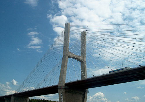
pass the city of Cape Girardeau, MO at the 52 MM and it
prominently features a new suspension bridge completed in the past year.
I
pass the city of Cape Girardeau, MO at the 52 MM and it
prominently features a new suspension bridge completed in the past year.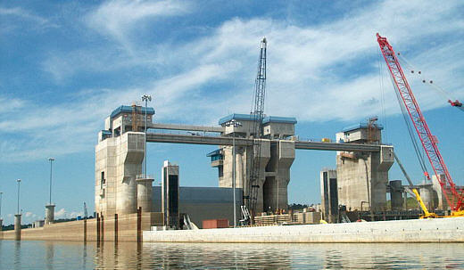 The next major attraction is
  The Ohio River
is also a big river.
The Ohio River
is also a big river.