|
Page #4
And the ramps weren’t the only things narrow. First I want to comment that ALL of the roads I traveled in Kentucky were in excellent condition. Even the out of the way, in the woods, down by the river, back roads were blacktop and extremely smooth. BUT WERE THEY NARROW. You certainly can’t accuse them of wasting blacktop. Some of the roads were striped as two lanes but in Illinois they would be considered a decent single lane. And there were no shoulders.
Pool #5 was one of the shorter runs at 14 miles long. It provided some nice scenery and again a distinct lack of other boat traffic. When I reached the decommissioned Lock #6 I founded that it was silted in near the miter gates but I was able to moor at the end of the longwall and climb up the ladder for a look around. There was a fisherman on the lock wall and we talked a little about the lock and the area while we watch gar swimming around in front of the gates feeding on the thousands of minnows that made the water boil. He gave me a suggestion as to which ramp to use for Pool #6 and I took note.
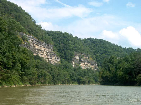
Pool #6 is 21 miles long and its first seven miles or so are similar to earlier ones. But then things start to change. The cliffs start to climb and their rock faces begin to dominate the scenery. It was at this point I realized I had left my camera in the truck. I thought about just forgetting the photos but the more I looked the more I wanted it. And I remembered the couple at Frankford telling me that #6 and #7 were the most enjoyable. Back seven miles to get it.
At mile marker 113 the river becomes even more of a treat as it offers a first for my boating experiences. The Kentucky becomes a self-guided tour for the next 62 miles. When I was at Lock #1 the lockmaster had given me a 25-page brochure and map prepared by the Jessamine County River Task Force. As you travel this section of the river there are numbered signs along the shore that corresponds with the map and text and offers interesting tidbits of river history and a few current events. This is a unique and cleaver device to enhance the experience of the river. I will mention I couldn’t locate a few of the markers but I attributed that to the higher than normal water levels and the fact that they were probably submerged.
Pool #6 ends at Lock #7 and again I go ashore to have a look. This time I pull in a little downstream and walk to the lock and dam. I note that it has a small operating power generating plant – the first I had seen on the Kentucky River. A sign states that it is totally automated facility and list the times of the day when water is released. This serves as a warning to fisherman that often work the tail waters.
I make the return trip and once again enjoy the panoramic view. For me I just doesn’t get much better than this – or so I thought.
A half-mile upstream from there is the Shaker Landing where an operating paddlewheel tour boat is moored. Nearby is Pleasant Hill, a restored Shaker community open to the public. And the scenery continues to get better as the cliffs grow and wrap 180 degrees around tight hairpin turns. Extraordinary……….. Then another 1/2 mile about mile marker 131 is Chimney rock (called Candle Stick Rock on the chart) a unique geological formation.
At mile marker 135 is Camp Nelson. Today there are RVs along the shoreline but during the Civil War this area was a Union camp. It is of note to me because of an interesting engineering achievement. Five miles upstream the Union army built a waterworks. A stream pumping station was built on stilts 35’ above normal pool and pumped water from the river 470’ up the cliffs to a reservoir on top the bluffs. From there the water was gravity feed through out the camp that was about 1 1/2 miles away overland. Not bad for 1863.
All the way to Lock #8 the extraordinary views continued. I stopped to check out the lock but didn’t stay long as I was anxious to make the return run. At one point I brought Therapy to a stop and just drifted in the lazy current while I gazed up at the sheer rock walls. It was so quite and peaceful it is hard for describe. For me one of the biggest draws of my river trips are the solitude sometimes found so here on the Kentucky River I was in heaven. I know it sounds silly but at one point I remember noticing my cheeks starting to hurt from smiling so much. This indeed was the most enjoyable river passage I have yet to make.
As I was leaving the ramp area I decided to swing into High Bridge Park on the bluff overlooking the river. I found it to be a small immaculate park giving and excellent view of the bridge and the river below. There was a large open pavilion with a hardwood floor and ceiling fans, smaller picnic shelters, observation platform and grass-covered areas all beautifully maintained.
|
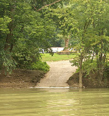 The ramp for pool #5 was about 20 miles away.
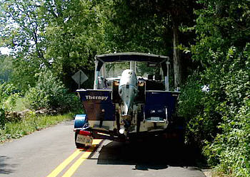 On one of the narrower sections I couldn’t help
myself and had to hop out and take a photo of the trailer.
On one of the narrower sections I couldn’t help
myself and had to hop out and take a photo of the trailer.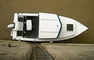 It wasn’t long and I was back loading Therapy on
the trailer and hitting the road for the next pool.
It wasn’t long and I was back loading Therapy on
the trailer and hitting the road for the next pool.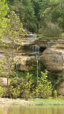 And I am glad I did.
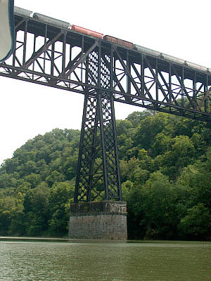 The next stop on Pool #7 was
25-mile drive to the ramp at High Bridge. The brochure explained the
name was derived from a railroad bridge constructed there in 1876.
The next stop on Pool #7 was
25-mile drive to the ramp at High Bridge. The brochure explained the
name was derived from a railroad bridge constructed there in 1876.