|
As I approach what looks like the highest section with no hanging cables I start to doubt I have clearance. The closer I get the tighter it looks. In order to know for sure I need to walk back to the cockpit and look over the pilothouse to see it the radar unit and anchor light will clear. This means letting go of the wheel and allowing Therapy to pilot itself in the heavy current. This has even a higher pucker factor when you realize that the area I am trying to pass is fairly narrow and if Therapy suddenly swings to the side in the swift current she will most likely smack the steel structure.
I ease up very slowly letting go and stepping back several times to try to judge the clearance. Wow, its close!! But I think it will go! I edge on forward and clear by no more than and inch. Way too close, but I’m under!
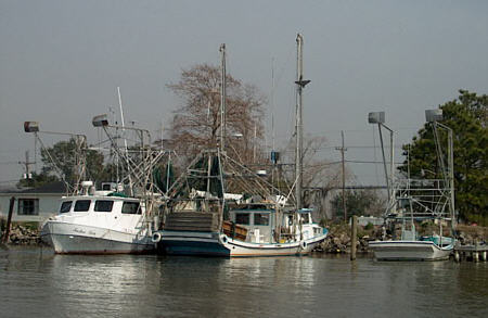
I am now on the Morgan City side and can make out the dock area. Commercial fishing boats use the biggest part of this but on the far end there are a few slips reserved for pleasure craft. But all slips are not created equal. In this case they consist of four post sticking six feet out of the water positioned in a square about 16’ apart. There is no walkway, not even a short one, on the sides. Boarding must be done either over the bow or transom.
It takes about 45 minutes for me to figure out how to secure Therapy to the four widely spaced post (my attempts to lasso them cowboy style prove to be an utter failure) I manage to rig up a system where I can get off over the transom and then pull Therapy away from the dock (I also need to be able to retrieve it when I return!). Finally I manage to get to shore feeling Therapy is safe and without falling in the river. I walk up several blocks and find a fast food fried chicken place and a newspaper. Not my ideal meal but satisfying and relaxing none the less.
After an hour or so I walk back and retrieve the boat and go aboard. It is not until then that I realize the full consequence of my location. I am moored directly under Highway 90 Bridge, which carries a lot of traffic. Quiet it is not. In fact, when a semi trucks pass over it sounds like thunder. Not distance thunder but up close and personal thunder. Oh well, I’m here for the night.
The next morning the first thing on the agenda is to decide where I am going from here. I need to address the fact that the typical pleasure I experience when on the water has been somewhat dampened by the stress of not having a chart and knowing for sure where I am going. Last night in got me into trouble and I just wasn’t sure if I wanted to find myself there again. Looking at Quimby’s revealed that the next services were 65 miles away. From there I would need to pass through two locks and cover another 80 miles to the next services. Plus now it had started to rain.
I though about it for a while. Although the bayou and marsh scenery maybe beautiful to many, I honestly was thrilled with the miles and miles of scrub trees and grass. I decided I really didn’t want to continue west another day and then the next return the same way through the same terrain. I thought I would go back to where I started and maybe return to Grand Isle or perhaps head towards New Orleans.
I could have just taken the lock but my stubborn streak was shinning bright and I was adamant that I was going to find the cutoff. Finally, there it was! The problem seemed to be an error in the GPS’s database. It was showing a Bayou Chene and that’s were I was looking but it was mislabeled and the actual correct location of the bayou was two miles away. Once I realized this I was able to trace the canal on the GPS screen and “see” the correct course for the bypass.
The return trip was uneventful. The swing bridge at Morgan City was open so I passed through with no problem after refueling. I also caught the floating bridge open for other traffic and passed by with no delay. The light rain continued but I was in the dry and it was doing an admirable job of washing off the salt-water spray. All was fine with the world.
|
 About
a mile and a half past the lock the amount of industry and lights
reduce. I am approaching an intersection with the Atchafalaya River and
need to travel up it about a half mile to the Morgan City Public Dock.
Suddenly I transition from almost still water to a heavy current
pushing against Therapy’s bow at 4 mph. From Quimby’s
description I know that the dock is between a railroad bridge and a
highway bridge. It is much darker here and my eyes are still not
adjusted from all the lights. Struggling trying to
see, I slowly make out a low structure that I realize is a
swing bridge. I again am not sure how to contact the
bridgetender and really don’t want to hang around out here in the dark,
fighting the current and dodging the other traffic. I decide to ease
forward and see if I can once more squeeze under.
About
a mile and a half past the lock the amount of industry and lights
reduce. I am approaching an intersection with the Atchafalaya River and
need to travel up it about a half mile to the Morgan City Public Dock.
Suddenly I transition from almost still water to a heavy current
pushing against Therapy’s bow at 4 mph. From Quimby’s
description I know that the dock is between a railroad bridge and a
highway bridge. It is much darker here and my eyes are still not
adjusted from all the lights. Struggling trying to
see, I slowly make out a low structure that I realize is a
swing bridge. I again am not sure how to contact the
bridgetender and really don’t want to hang around out here in the dark,
fighting the current and dodging the other traffic. I decide to ease
forward and see if I can once more squeeze under. I
decide to enter stern first, which will make exiting the boat easier,
but there is also a fifth post sitting dead center of the slip to
protect the dock. Naturally this will line up with the
outboard. If I moor close enough to get off, I risk
possible damage when the wake from passing barges shoves Therapy
towards the shore. If I secure it far enough away from the
post to be safe, I can’t get off the boat. And I really want to go
ashore and find something hot to eat.
I
decide to enter stern first, which will make exiting the boat easier,
but there is also a fifth post sitting dead center of the slip to
protect the dock. Naturally this will line up with the
outboard. If I moor close enough to get off, I risk
possible damage when the wake from passing barges shoves Therapy
towards the shore. If I secure it far enough away from the
post to be safe, I can’t get off the boat. And I really want to go
ashore and find something hot to eat. With
this decision made, the next item was the lock. I really
wanted to forgo it but that meant I needed to find the bypass. I spent
the next 20 minutes messing with the GPS trying to figure out where it
was located. The area around Morgan City is somewhat
confusing. There are waterways running from it in every
direction. Trying to figure out what was the ICW, what was
the Atchafalaya River and what were just other canals boggled my mind.
And everything seemed to connect to everything else yet I couldn’t get
to where I wanted to go. The obvious answer is HAVE THE RIGHT CHART,
FOOL!
With
this decision made, the next item was the lock. I really
wanted to forgo it but that meant I needed to find the bypass. I spent
the next 20 minutes messing with the GPS trying to figure out where it
was located. The area around Morgan City is somewhat
confusing. There are waterways running from it in every
direction. Trying to figure out what was the ICW, what was
the Atchafalaya River and what were just other canals boggled my mind.
And everything seemed to connect to everything else yet I couldn’t get
to where I wanted to go. The obvious answer is HAVE THE RIGHT CHART,
FOOL!