 A little farther upstream at the 424 mile marker I encounter the
final manmade barrier before Chattanooga. Nickajack Lock and Dam is
by far the newest lock on the Tennessee River. It was completed in
1967 and normally accommodates a 40 feet lift to the lake. A call to
the lockmaster brings a smile to my face as he (it is a male this time) informs
me that lock is already empty and all he has to do is open the doors and
let me in. Finally, a clean pass!
A little farther upstream at the 424 mile marker I encounter the
final manmade barrier before Chattanooga. Nickajack Lock and Dam is
by far the newest lock on the Tennessee River. It was completed in
1967 and normally accommodates a 40 feet lift to the lake. A call to
the lockmaster brings a smile to my face as he (it is a male this time) informs
me that lock is already empty and all he has to do is open the doors and
let me in. Finally, a clean pass!
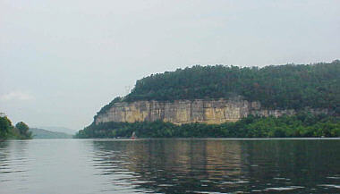
Heading up the lake from this point is a pure delight. If you can not find the time to make this entire run down the Tennessee at least try to complete the 40 miles of river between Nickajack and Chattanooga. It is called the Tennessee River Gorge and sometimes referred to as the “Grand Canyon” of Tennessee. Although this might be a bit of an overstatement it is indeed a beautiful ride as you wind through the Smokey Mountains. Actually, I had more or less been here before but didn’t realize it until I rounded a bend and saw the I-24 bridge. Several times when driving south on the interstate I had crossed the bridge and admired this lake. I had promised myself that some day I would drag the boat down here and explore it. When planning the trip I didn’t realize this scenic lake was actually part of the Tennessee River.
The story I read said the lock and dam was built by the private sector in 1913. In 1939 it was acquired by TVA. It appeared that the dam had been built on stone that was fractured and allowed water to flow beneath it. Also the lock as whole was in disrepair and as result the Corp decided to remove the dam an replace I with Nicajack. I assume it was not cost effective to tear down the old generating plant structure so it remains today slowly being consumed by the elements. The ride from here to Chattanooga is indeed superb as the river winds through the tree covered Smokey Mountains. Near mile marker 444 I come upon a strange concrete structure built into the side of a mountain. There is what appears to be a concrete retaining wall on the river bank and three large “tunnel” entrances going into the mountain.
A few miles farther at mile marker another landmark passes by. Here the river flows around the base of Lookout Mountain. This is the site of a historic Civil War battle and the country’s first military park – Chickamauga and Chattanooga National Military Park Chickamauga and Chattanooga National Military Park. Also around this point Interstate 24 begins to follow the river’s edge for about two miles. I have passed this way several times before by car but today the view and enjoyment level is greatly exceeding the drone and boredom of wheeled travels.
|
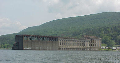 About two miles upstream from the bridge I come upon an interesting
sight. Here are the decaying remains of the Hales Bar Lock and Dam.
The dam has been removed but the shell of the power plant still looms from
the water. Across the channel are the old locks. Their gates have
been removed they are now used as a coal loading facility.
About two miles upstream from the bridge I come upon an interesting
sight. Here are the decaying remains of the Hales Bar Lock and Dam.
The dam has been removed but the shell of the power plant still looms from
the water. Across the channel are the old locks. Their gates have
been removed they are now used as a coal loading facility.
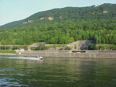 Turns out that this is the Raccoon Mountain power generating station.
Like the hydroelectric dams along the Tennessee it uses water power to generate
electric but with a twist. Here when demand for electricity is low (therefore
the cost per KW is low) water is actually pumped up into a man made lake
on top of the mountain. It is held there until demand is high and then the
water is released. It runs down internal chutes and is directed into
generators and electricity is produced. Because electricity can be
sold at many times a higher price during peak demand it makes the whole scheme
profitable – the classic buy low, sell high.
Turns out that this is the Raccoon Mountain power generating station.
Like the hydroelectric dams along the Tennessee it uses water power to generate
electric but with a twist. Here when demand for electricity is low (therefore
the cost per KW is low) water is actually pumped up into a man made lake
on top of the mountain. It is held there until demand is high and then the
water is released. It runs down internal chutes and is directed into
generators and electricity is produced. Because electricity can be
sold at many times a higher price during peak demand it makes the whole scheme
profitable – the classic buy low, sell high.