 I
slept fairly well the rest of the night. About 5:30 the sun was starting
to come up and I was anxious to get moving. There was a modest amount
of fog but visibility wasnt too bad so I fired up the Honda and pointed
the bow south. As I made cruise speed I noticed that a few fisherman
were already wetting their lines. Surprisingly during the night the
wind had exhausted itself and the entire lake was like glass. I
slept fairly well the rest of the night. About 5:30 the sun was starting
to come up and I was anxious to get moving. There was a modest amount
of fog but visibility wasnt too bad so I fired up the Honda and pointed
the bow south. As I made cruise speed I noticed that a few fisherman
were already wetting their lines. Surprisingly during the night the
wind had exhausted itself and the entire lake was like glass.
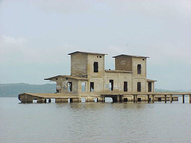
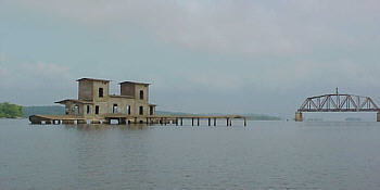
At about the 62 mile marker I cross into Tennessee and continued on until a came to 78.3 mile marker. Here was an unusual sight and I stopped to take a few pictures. It appeared to be an old loading facility that at one time sat on the bank of the river. But now in this area the river is actually a lake and the shoreline is a half-mile away. The concrete structure that once server the river is now being slowly consumed by it. If the hazy view of the building wasnt surreal enough on its own in the background was an abandon railroad bridge. Part of its span was removed from the navigation channel but the rest of it was allowed to stand and come abrupt end over the lake. The sight summons numerous memories of B&W movies with steam locomotives hurtling off the bridge after bandits blew it up.
At mile marker 206 I reach Pickwick Landing Lock & Dam. As with all the locks and dams I will encounter on this trip it serves a dual purpose of making the river navigable and generating electricity. It was built in 1938 and has a 1000x 110main lock and smaller 600 x 110 auxiliary lock. When I arrived there was a towboat with a nice compliment of barges waiting for the lock. This wasnt good. Before I left home I had checked the Internet Notice to Navigation Interests for the Nashville District of the Corps of Engineers* and knew that their auxiliary lock was out of service for maintenance. A call on the radio confirmed my suspicions. An apologetic lockmaster explained she was just lifting a barge up to the lake and once it exited another would enter and be lowered. But after that there was still another tow in front of me and I would have to wait for him to lock through. She said she would give me a call when I could enter. I took a deep breath and asked for a time estimate of the wait. The reply, Probably about three hours! This really wasnt a surprise. I was prepared possible long waits at locks and had brought along a couple of good books. Propping my feet up I settled in as the rain dripped from the cabin roof. Hey, it could be a lot worse I could be at work. The lockmaster estimate was very accurate and in just a little over three hours I was lifted 52 feet and heading out onto the 43,100 acre Picwick Lake. Just eight miles up stream at the 215 mile marker I come to the Alabama state line and the entry to the Tennessee-Tombigbee Waterway. This is a very popular route for the snowbirds heading to Florida. Traveling its 450 miles course will bring you to Mobile, Alabama and the Gulf of Mexico. This is a trip I would like to make some day but it includes a dozen locks. That trip would be about the same amount of miles as this one but obviously I will need to allot more than the six days. Yes, someday but today its the Tennessee River and I cruise along as my path starts to turn more easterly. In my eyes any body of water that is more than a mile wide is a lake not a river. There is no geological basis for this as it is just my perception. Around the 242 mile marker the Tennessee becomes a river again I feel more at home in my small hand-hewn craft. A couple of miles upriver at marker 247 it splits in to two channels and becomes very narrow for the next seven miles. |
 Continuing
upstream at mile marker 100 the lake starts to narrow and after 14 miles
more it becomes what I call a river. It is only about a 400 yards wide
and its course begins to wander as it seeks the path of least resistance.
The wind is still calm and the water is reflecting the tree covered shoreline
like a mirror. The sky is overcast and a few raindrops fall now and then.
But the ride is smooth as silk and the sound of the water sizzling off
the chines reminds me of why I love boating so much.
Continuing
upstream at mile marker 100 the lake starts to narrow and after 14 miles
more it becomes what I call a river. It is only about a 400 yards wide
and its course begins to wander as it seeks the path of least resistance.
The wind is still calm and the water is reflecting the tree covered shoreline
like a mirror. The sky is overcast and a few raindrops fall now and then.
But the ride is smooth as silk and the sound of the water sizzling off
the chines reminds me of why I love boating so much.