|
Exploring the Green River And the coal company came with the world's largest shovel
And daddy, won't you take me back to Muhlenberg County
But it wasn't until almost 30 years later that I became aware of the total significance of the lyrics. I was looking around for another river adventure and by chance happened onto the Green River in Kentucky. I consulted my Rand McNally and found that its mouth was on the Ohio River near Evansville IN. From there running upstream on the Green takes you south into the heart of western Kentucky. Evansville is about a 2 1/2 hour drive from my home which is a very acceptance tow distance. It looked promising. Because the Green is a rather small river I was surprised that there was a chart available from the Corps of Engineers. I ordered it and it arrived in a couple of days. Studying the chart I found that the river was originally navigable for about 170 miles. But because of low traffic and failure of Lock #4 back in 1965, Lock #3 had been placed in "caretaker" status (more on this later) as stood as a road block at mile marker 108. Nonetheless it looked like a nice trip and a friend and I decided to make the run (once again leaving our wives to work!). When looking at the chart I suddenly began to see that the song lyrics stored back in the cobwebs of my mind were about this river. The Green passes through Muhlenberg County and along the way at mile marker 100 is a small berg called Paradise. Also shown on the chart was a Peabody Coal Company loading facility that serviced their very large strip mining operation in the area. So in my youth I had sang along with this song about a river in what I thought was a fictional place. Now I find myself ready to navigate its very real waters. Interesting how life's experiences some times seem run in circles. When planning any type of river trip in an unfamiliar area there are always questions that need to be answered before departure. In this case the first order of business was to find a place to drop in and then leave the truck and trailer. My friend and co-pilot for this trip, Aldi, had purchased his 20 ft Allison go fast boat from a dealer in Evansville and called there to ask for some information about the area facilities. An employee said he had just the spot and gave him directions to a public ramp. He described it as being on the Kentucky side of the Ohio River just across the bridge from Evansville at Henderson, KY. Since the location was just across from Evansville I didn't take the time to locate it on the Ohio River chart. No big deal right?
When the chosen date arrived we tied on to Therapy (the name I had finally chosen for my Cabin Skiff) and hit the road. We had departed in the early afternoon and our game plan was to stop and eat our evening meal on the way. We would then drop in and head upstream a ways and anchor for the night on the Green River. We arrived a little later than expected but really wasn't concerned. The mouth of the Green River is only about 9 miles upstream from Evansville. But here we encountered problem #1. On the ramp there was a sign that stated that a permit was required to use the facility. It continued that the city police patrolled the area and tickets would be issued to anyone parked there without the permit. Permits were available at City Hall Monday through Friday - 8:00 am to 4:00 pm .. It was 7:00 pm on a Friday evening! Now what? After talking it over a few minutes we decided there was no choice. We would park there and if we got a ticket, so be it. It would just be part of the trip expense. We dropped on to the Ohio River and pulled from the ramp and tried to get our bearings. Looking around Evansville was nowhere in sight. Because the ramp was supposed to be "Just across the river from Evansville," I hadn't bothered to bring along the Ohio River Chart. We knew it had to be upstream so surely it would be just around the next bend. We rounded the next bend and no Evansville. We rounded the NEXT bend and no Evansville. Finally, nine miles later we found Evansville. Although the ramp was probably only 3 miles as the crow files from Evansville it took nine river miles to get there.
We head for the marina but our hopes sank when we find it is closed for the evening and won't be reopening until 9 am the next day. Decision time. But we really don't have many choices. We had come to make this run and one way or the other we were going up the Green River. The only question now was how far. We decided we would go up to Calhoun at the 64 mile marker and try to buy fuel and carry it to the boat. This was complicated because to save the space and weight I decided not to take along any empty fuel containers. The reasoning was a little weak then but looks down right dumb now. So not only would we need gas but a 5 gallon container to put it in. Worst case was that we could not get fuel. If this happens we would run as for as 15 gallon would take us. This would leave the other half a tank to get us home and the difference between up stream and the return downstream should yield us some reserve. This would mean we would have to return without reaching the end of navigational channel. Not a huge deal but somewhat disheartening. This bugged us a little more because this was not our first ATTEMPT at the Green River. Last fall we had dropped in on the Ohio River at Golconda, IL. and ran up to the Green intent on running to the end. In my planning I had failed to check the notices posted by the Corps of Engineers and we found the first lock down for repair. Green River - 1, Boaters - 0. Now it seemed the river was going for 2 and 0. With the decision to go made we continued on up stream to the mouth of the Green. Unfortunately things were really busy on the Ohio and the barges had really chopped up the water. But worse than that it was now starting to get dark! My gut tells me the best bet would be to try to find an acceptable spot on the Ohio and set out the night. Aldi is not wild about anchoring on a busy river with barges going by all night. He has a good point - probably not the safest place to stay. But my memory of the Green River from the mouth to the first lock which is nine miles up stream was of a very narrow river with few if any opportunities for anchorage. The chart more or less confirmed this but we're small and don't need much space while hanging on the hook. Again, after a brief discussion we decided on the Green River.
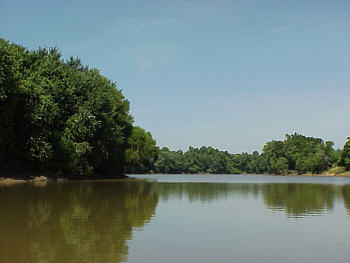
Now let me say right here I have a sincere respect for river barges and normally give them a very wide berth. But our situation was deteriorating. Plus, it was a small tow with only a few barges and moving slower than normal because of the confined space. The risk seemed acceptable but I was still closer than I had ever been to a moving tow and hope to never be that close again. We made a clean pass and continued up stream figuring maybe now our luck was starting to change. But the Green River was not yet ready to offer us its blessing and seem intent on making us earn passage. Unknown to us was the week before the river had been flooding upstream. The water and current were now at normal levels but there was still a lot of debris floating down. Nothing huge, just lots of little stuff and some up to 4" in diameter or so. During the day this is just somewhat of an aggravation but with the light fading to dark the pucker factor was increasing. Peering out the windshield in the twilight trying to spot the bigger hunks and then cringing when I hear a dull thud on the wood hull was a little tough on the nerves. It really made me think about how thin 3/8 plywood is and what exactly it might take to breech it! I had slowed to minimum planning speed as we plowed on south searching for an acceptable anchorage. There was nothing. The river was only about 350 feet wide and we just couldn't locate any thing we felt it would be safe. And by then was dark! There was no moon so we had to break out the spotlight and try to scan the surface for those floating mines. We timidly continued our search but it had become obvious that our only refuge would be at Lock #1 at the 9 mile marker. As we made a slight bend the lights of the lock came into view and we made our way over to the dam side of the river. Here we dropped anchor, set-up the lawn chairs in the back of the boat and plopped down our somewhat stress bodies. The night sky was overflowing with stars and the sound of water flowing over the dam created a tranquilizing affect. Sure, it could have been a little bit better trip so far but Aldi and I both have an cliché we repeat often - "A bad day on the river is still better than a good day at work." And when I think about it, in 25 years of boating I have had some "interesting experiences" on the water but not one do I consider a "bad" day. The dawn broke to a beautiful morning. We had both slept well and were ready to continue our quest to Lock #3 at Rochester, KY. We tried to raise the lockmaster on the radio but had no luck so we idled over to the lock wall and pulled the chain to request lockage. After a minute or two the gates opened and we entered tying up on the floating bollards on the port side. As we were lifted about 8 feet the lockmaster came by and we talked a while. We asked about fuel availability and he confirmed that there was no gas on the river. He did add that at Calhoun there was a small dock, gas stations and a couple of restaurants in walking distance. We thanked him for the information as we idled out of the lock. Things were looking up. Maybe we had passed the Green River's test the night before. At any rate it was a beautiful morning and we were on the water. For me it just doesn't get much better. As we continued upstream the ride was comfortably uneventful. As I said before the Green is fairly narrow but we also found it was deep at 30 to 40 feet in most places. The tree covered banks are mostly steep as the river runs through rolling hills. Although there was some current, it was tame at about 1 MPH. Still there was the debris in the water that required constant attention. Often I would find myself scanning around at the passing shore enjoying the view when a thump on the hull would remind me to take notice of the water ahead.
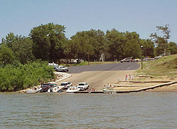
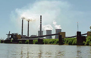
Really, I can't blame this on the river. Obviously it was shallow - the guys were standing for heavens sake! I was so intent on looking at the odd sight I neglected my duty as a captain and was not watching the depth sounder. I shut it down and the current carried us to deeper water. We raised the engine to take a look and fortunately the damage was minor. One blade of the aluminum prop was bent but we could see no other injury. The Honda outboard trims up high enough that the entire lower unit is out of the water so making a prop change while standing on the swim platform is no problem. Also, on trips like these I always carry TWO spare props so there was no real concern - only that I could just kick myself for not paying attention. Some of you may be thinking, "Why is he running aluminum props when stainless steel is so much more durable. The answer is that one of my spare props IS stainless made by a big name manufacturer. The problem is that the two Honda aluminum wheels out perform it hands down. I called and talked to the company about this as I had read the stainless will almost always yield better results than aluminum. They said that is "usually" true but not always. And it appears on my boat it is not the case. Lovely, I now have a $380 prop I use as a last resort backup and run the $120 aluminum units. But I digress . Once again we can't raise the lock on the radio and find a chain to pull for the signal. Entering the lock we notice that there are floating pins to tie off on but they are only one side of the lock. I find this unusual as all the other locks I have been in have them on both sides. The lift to the other side is about 12 feet and as we exit the lock we are on the edge of Calhoun, KY. A short ways up the river is the small floating dock described by the lockmaster. We get out and stretch our legs and investigate the availability of gasoline. Calhoun is a small town with a population of about 900 but is the county seat of McLean County. The courthouse is the predominate feature of the downtown area. And as we walk along I decided that Calhoun may hold the national record for the town with the highest number of attorneys offices on a per capita basis! We pass a couple of restaurants but walk up hill about 10 blocks before we find a gas station. On the other side of the street there is a small hardware store so we cross over to see about a gas can. Fortunately they have some and as we are waiting to checkout we notice a photo of the lock hanging on a post near the register. The owner sees us looking at it, which leads us into a conversation about the river. As it turns out he worked most of his life on towboats running the Green. He retired from river life and now runs the store. We swap a few stories and explain that we are from Illinois and are running up the river to Lock #3. He tells us that if we get there in time and want to return to Calhoun that we can take in a free concert that evening on the river front. Sounds good to us as we can also hit one of the restaurants for dinner. With our empty gas can in hand we head back down towards the river. We decide to swing in to one of the gas stations / quick marts to check about their hours. We really didn't want to get the gas now but wanted to be sure they were open later. No problem - open 24 hours. While we are in there we decide that even though it is about 10 am it's time for a little snack. We look around to make sure are wives arent somehow there watching us (they should be 150 miles away at work but you can't be to careful) and both of us buy a pint of ice cream. We head back to the boat and by the time we get there it has thawed just enough to eat so we wolf it down. Not a bad brunch. Continuing on south again proves uneventful but still dodging flotsam. At one spot we do have to drop off plane and negotiate through a log jam of debris that covers the width of the river. Also, we note the high number of abandon coal loading facilities now rusting in the warm Kentucky sun. There were a few active power plants and interestingly coal was being barged in to some of them.
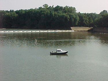
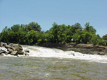
We ease out way up to the dam (watching the depth sounder this time) and climb out on to the rocks and wander around. I really wanted to look down into the lock but it was not accessible from the dam or the near by shoreline. But it is obvious from what we can see this lock will never open again It is in a serious state of disrepair and we comment that if this is "Caretaker Status" we want the job of caretaker. It obvious hasn't been touched in years. After snapping a few photos of the area and Therapy we climb back aboard and drift downstream about 100 yards and get over out of the current. There we have a sandwich for a late lunch and watch the fishermen working the bank. The water plowing down over the dam along with the rock formations it has cut creates an interesting image and warrants a few more photos. With our stomachs satisfied it is time to head back to Calhoun. We retrace our wake and slow down as we round the bend approaching the logjam. To our surprise it was gone which just highlights how quickly things can change on a river. On the return we do pass one towboat heading down stream but barge traffic was low for the entire trip.
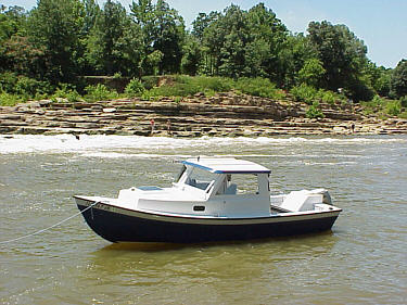
We dumped the gas in the tank, which put our fuel concerns to rest. By now it was about 5:30 pm and we decided it was time for dinner. We walked up to the "Lighthouse Restaurant" and took a seat beside a picture window the looked down on the river and provided a great view of the Lock & Dam on the edge of town. The restaurants name may not be real original but the all you can eat fried catfish dinner was excellent and very reasonably priced. As we waddled out the door my sweet tooth kicked in and we walked across the street to Jays for dessert in the form of an ice cream float. We consumed these walking back to the boat. When tossing the used cups in our onboard trash bag we laughed when Aldi pointed out that more than half our trash was ice cream containers! By now the band was getting ready to fire up the music and we backed away from the shore for a better view and dropped anchor to watch the show. Because the design of Therapy is unusual to this part of the country, anytime it is setting still people always stop by to ask about it. This was no different as a couple in a nice big fiberglass deck boat idled by and had a few questions. They ended up tying on beside us and we spent the evening talking while we listened to the music. When the concert came to an end they ask were we planned to spend the night. When we told them we were going down by the lock they would have nothing to do with it. They lived just a couple miles back up the river and had an open slip in front of their home they insisted we use. We followed them back and tied up and they invited us up to their house were we spent the remainder of the evening just shooting the breeze, drinking a few refreshments and watching TV. They offered us the use of a spare bedroom and shower but at that point we really felt they had done enough. They also offered to fix us breakfast but we were planning and early start and declined. These were really nice people. If you happen to read this Ken and Cindy - Again, thanks a lot! The remaining river miles passed without a hitch. We locked straight though both locks again with no wait. Since we had the extra fuel we made the decision to run up the Ohio River about 8 miles to the Newberg Lock and Dam. We knew that the main lock was down for service so we thought we would just take a look. Along the way we spotted the Angle Mounds Public Access Area at the 782 mile marker. It is on the Kentucky side of the river and is only 2 miles from the mouth of the Green River. Obviously it would have been a much better choice for a launching site. As it turned out we would have had just enough fuel to have made it back to the Evansville marina without the 5 gallons but we would have had less than a gallon left in the tank. We couldn't have made it all the way to the ramp. That's a little too close so getting the extra gas certainly wasn't a waste. Plus it was our quest for fuel that allowed us to meet the kind gentleman working on his lawn, directed us to an enjoyable concert on the river and allowed us to spend the evening with two of Kentucky's finest residents. So in this case our cloud did have a silver lining.
Although the trip had started off a little rough the Green River
must have indeed given us her blessing and offered up a really nice trip.
Like I said earlier, there is never a "bad" day on the river but some are
just outstanding. I'd rate this one right up there.
|
 In
the early 1970's I enjoyed the music of John Denver as did many young adults.
The words to one of his songs had a familiar theme and have always stuck
in my mind as result. I had been born and raised in Southern Illinois
coal country and Peabody Coal Company had a major presence in my area.
In fact, my father worked for Peabody for most of his career and I too
spent a couple of years working at one of their mines. The Denver song
"Paradise", quoted above, made reference to the destruction that was a
byproduct of strip mining and named Peabody as the perpetrator - that was
kind of cool when your 20 years old. (The song was written by a Kentucky
native, John Prine, who was later sued by Peabody Coal because of the reference
to their mining operations.)
In
the early 1970's I enjoyed the music of John Denver as did many young adults.
The words to one of his songs had a familiar theme and have always stuck
in my mind as result. I had been born and raised in Southern Illinois
coal country and Peabody Coal Company had a major presence in my area.
In fact, my father worked for Peabody for most of his career and I too
spent a couple of years working at one of their mines. The Denver song
"Paradise", quoted above, made reference to the destruction that was a
byproduct of strip mining and named Peabody as the perpetrator - that was
kind of cool when your 20 years old. (The song was written by a Kentucky
native, John Prine, who was later sued by Peabody Coal because of the reference
to their mining operations.)
 With
a launch site chosen we then needed to check on fuel availability.
Not good! There were no marinas on the Green River and actually from
looking at the chart and mapping programs it appeared that there was only
one town might be accessible to carry fuel to the boat in a 5 gallon container.
But I ran the numbers and based on my fuel burn rates established on the
Tennessee River trip it look like we could make the 234 mile roundtrip
run with the 30 gallons of onboard fuel. It would be close as our range
calculated to 255 miles but still acceptable.
With
a launch site chosen we then needed to check on fuel availability.
Not good! There were no marinas on the Green River and actually from
looking at the chart and mapping programs it appeared that there was only
one town might be accessible to carry fuel to the boat in a 5 gallon container.
But I ran the numbers and based on my fuel burn rates established on the
Tennessee River trip it look like we could make the 234 mile roundtrip
run with the 30 gallons of onboard fuel. It would be close as our range
calculated to 255 miles but still acceptable.
 But
now we had another problem. Watching the fuel flow meter revealed
that we were burning fuel at a higher rate than expected. The addition
of a 170 lb passenger and his gear was making the 50 hp Honda work harder
and it was burning fuel at the rate of about 8 MPG. Plus, the trip
had just now become 18 miles longer than expected. The numbers didn't look
good as they projected a burn of about 32 gallon with no reserve. (Once
you run an airplane out of gas and have to make a forced landing in a soybean
field where you end the ride upside down hanging from the seat belts, you
develop a real aversion to running out of gas!) We were aware of a marina
at Evansville that had gas available. If we could swing in there
and top off the tank now and then do the same on the return trip we still
should be able to make it. A closer call on fuel than before but
it should work, especially when you consider that as we burn fuel and empty
the ice chest the decreased weight would allow MGP to increase.
But
now we had another problem. Watching the fuel flow meter revealed
that we were burning fuel at a higher rate than expected. The addition
of a 170 lb passenger and his gear was making the 50 hp Honda work harder
and it was burning fuel at the rate of about 8 MPG. Plus, the trip
had just now become 18 miles longer than expected. The numbers didn't look
good as they projected a burn of about 32 gallon with no reserve. (Once
you run an airplane out of gas and have to make a forced landing in a soybean
field where you end the ride upside down hanging from the seat belts, you
develop a real aversion to running out of gas!) We were aware of a marina
at Evansville that had gas available. If we could swing in there
and top off the tank now and then do the same on the return trip we still
should be able to make it. A closer call on fuel than before but
it should work, especially when you consider that as we burn fuel and empty
the ice chest the decreased weight would allow MGP to increase.
 As
we approached the mouth our lousy luck was still in control as there was
a barge just starting to enter. The first mile or so of the river is lined
with barges tied up to the shore, which makes the narrow channel even more
slender. If we wait and just follow the tow in, not only will we
be creeping along but may have a considerable wait if he decides to add
or drop off barges. And again it is getting dark and we need a safe harbor
for the night. It looks like we might have just enough room to squeeze
by on the port side so I take a deep breath and steer in that direction.
As
we approached the mouth our lousy luck was still in control as there was
a barge just starting to enter. The first mile or so of the river is lined
with barges tied up to the shore, which makes the narrow channel even more
slender. If we wait and just follow the tow in, not only will we
be creeping along but may have a considerable wait if he decides to add
or drop off barges. And again it is getting dark and we need a safe harbor
for the night. It looks like we might have just enough room to squeeze
by on the port side so I take a deep breath and steer in that direction.
 The
54 miles between Lock #1 and Lock #2 passed by in a little over two hours.
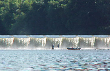
As we approached the lock we noticed a few fishing boats near the dam but
there were also fishermen "standing" in the tailwater just a few yards
from the dam wall. Curious, we eased our way towards them for a better
look. Once again the river just couldn't resist showing her superiority.
The boat suddenly pitched to the starboard and I heard the sickening sound
of rock kissing aluminum.
The
54 miles between Lock #1 and Lock #2 passed by in a little over two hours.
As we approached the lock we noticed a few fishing boats near the dam but
there were also fishermen "standing" in the tailwater just a few yards
from the dam wall. Curious, we eased our way towards them for a better
look. Once again the river just couldn't resist showing her superiority.
The boat suddenly pitched to the starboard and I heard the sickening sound
of rock kissing aluminum.
 The
remaining 45 miles go by quickly and we find ourselves approaching the
#3 Lock and Dam. The other two dams on the Green River were arched
metal structures and to me are more or less spillways. During low
water they hold pool but at other times the normal flow just runs over
the top the length of the dam. Number 3 also is a non-controlled
dam but is constructed of large boulders piled across the river and the
water runs helter skelter down through it at a fairly violent pace.
The
remaining 45 miles go by quickly and we find ourselves approaching the
#3 Lock and Dam. The other two dams on the Green River were arched
metal structures and to me are more or less spillways. During low
water they hold pool but at other times the normal flow just runs over
the top the length of the dam. Number 3 also is a non-controlled
dam but is constructed of large boulders piled across the river and the
water runs helter skelter down through it at a fairly violent pace.
 We
pull back in at Calhoun and decide to walk back to the station and get
the gas. As we fill the 5 gallon container neither one of us are
looking forward to the 10 block hike back to the boat carrying 35 lbs of
gas. We make it about a block and a half when we pass a local resident
out working on his lawn. Being a boater himself he knows what we
are up to and walks over and offers us a ride down to the boat. We're
all smiles as we drop the gas in the back of his truck and head to the
waterfront. We offer to pay him but he refuses. He tells us to have
fun and goes back to finish his lawn. Boaters are nice folks - but
we knew that didn't we.
We
pull back in at Calhoun and decide to walk back to the station and get
the gas. As we fill the 5 gallon container neither one of us are
looking forward to the 10 block hike back to the boat carrying 35 lbs of
gas. We make it about a block and a half when we pass a local resident
out working on his lawn. Being a boater himself he knows what we
are up to and walks over and offers us a ride down to the boat. We're
all smiles as we drop the gas in the back of his truck and head to the
waterfront. We offer to pay him but he refuses. He tells us to have
fun and goes back to finish his lawn. Boaters are nice folks - but
we knew that didn't we.
 We
got back to the ramp and it was a typical Sunday afternoon and things were
busy. We had to wait our turn to load the boat but I always enjoy
watching the other boats and people move around. Aldi walked up to
get the trailer and reported back that it was ticket free. So the city
of Henderson either didn't check or cut us some slack. Either way,
not a bad way to finish.
We
got back to the ramp and it was a typical Sunday afternoon and things were
busy. We had to wait our turn to load the boat but I always enjoy
watching the other boats and people move around. Aldi walked up to
get the trailer and reported back that it was ticket free. So the city
of Henderson either didn't check or cut us some slack. Either way,
not a bad way to finish.