Page 3
 Food is always important to me when on the water so I will relate my
findings. My first day out I stopped at Adam’s Landing/Pier Restaurant
at Quincy, IL (MM 327) for my evening meal. It was a very nice place
and I wondered as I went in if my t-shirt, shorts and sandals were appropriate.
I ask the waitress and she assured me it was just fine. Had a reasonably
priced meal of salad and two BBQ chicken breast. Went down well.
Food is always important to me when on the water so I will relate my
findings. My first day out I stopped at Adam’s Landing/Pier Restaurant
at Quincy, IL (MM 327) for my evening meal. It was a very nice place
and I wondered as I went in if my t-shirt, shorts and sandals were appropriate.
I ask the waitress and she assured me it was just fine. Had a reasonably
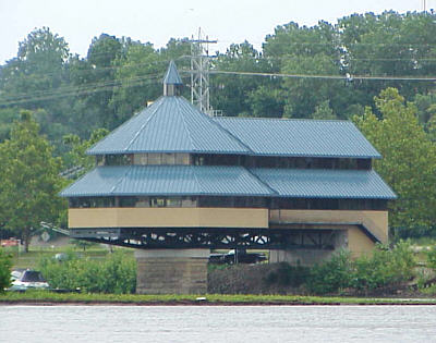
priced meal of salad and two BBQ chicken breast. Went down well. (Photo is Adams Landing) After eating I continued upstream and made it to Keokuk Yacht Club just after dark where I took a slip for the night. The price was $1.00 per foot so I paid $18. I thought it a little pricey for this part of the country but it came with electricity (which I didn’t use). The real reason I stopped was for the showers and that made it worth the price. They were clean and well kept. There were also coin operated laundry facilities if needed. Checking the GPS showed for the day I had covered 164 miles - not bad considering I was traveling upstream and had made it through six locks. On day #2 I stopped for and evening meal at LeClaire, IA at MM 497. Here there was a nice public dock and I walked just a block up to the main street where there were several restaurants. I decided on Sneaky Pete’s where they offered a western theme and a good steak dinner including salad bar. Down about a block from there was another restaurant that had an ice-cream parlor so I stopped in for a little sugar fix and then stretched my legs walking around a while. I continued on upstream and the end of my second day delivered me to Clinton, IA at MM 519. This added another 153 miles to the trip and 5 more locks. I anchored out in a slough near a marina and enjoyed watching the sunset from a lawn chair in the cockpit. The return trip started out uneventful other than rotten luck at the first lock. I pulled up anchor at 5:00 am and ran for an hour only to find a tow just starting to enter – a 2 1/2 hour wait. I might as well stayed in bed another two hours! I thought about hitting the sack again but I was having trouble getting the anchor to hold and I just didn’t trust it. The thought of going to sleep and being awakened by the sound of the hull breaking into pieces as it is being sucked though the dam tended to make me stay alert. 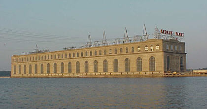 The next lock was much better as I passed through with no wait.
This was the first time I had shared a lock as there was a 50 ft houseboat
with four people onboard. I struck up a conversation with a man on the
rear deck holding a rope from the lock wall. I asked where they were
headed. He replied, “Florida!” He explained they were retiring
and in the process of moving their houseboat to Pensacola where it would
become their permanent home. Some guys have all the luck!
The next lock was much better as I passed through with no wait.
This was the first time I had shared a lock as there was a 50 ft houseboat
with four people onboard. I struck up a conversation with a man on the
rear deck holding a rope from the lock wall. I asked where they were
headed. He replied, “Florida!” He explained they were retiring
and in the process of moving their houseboat to Pensacola where it would
become their permanent home. Some guys have all the luck! (Photo is of power plant at Keokuk's Lock 19) By mid day the wind had kicked up and blowing about 12 to 14 MPH right up the river. In Therapy this produces a rough ride so I had to slow down and use the trim tabs to force the bow to cut through and smooth things out a little. I made it to Burlington IA where I decided to pull in take on some fuel and give my pounded body a break. Bluff Harbor Marina was a nice place to look around for a while and I ran into a gentleman that asked if Therapy was a C-Dory. I was surprised since I didn’t think anyone on this part of the world even knew what a C-Dory was! I told him it wasn’t. He told me he owned a 16 C-Dory and we compared notes for a while. Also, the marina has shower facilities they allow me to use free of charge. Nice people. I hung around for about an hour hoping the wind would die a bit but no luck. I decided to tough it out and made my way on to Fort Madison, IA at MM 338. Here I stopped at the North Shore Marina where I went into the Shadow Ridge Bar & Grill for something to eat. It was more bar than grill but still I had a good home-style burger & fries. I continued on and encountered my first real problem of the trip as dusk approached. In my zest to convert gasoline to river miles I had pushed a little farther into the evening than was prudent. Now with the light of day quickly fading I need a safe place to anchor for the night. I was in a section of the river that offered many islands and sloughs and to the casual boater it would appear to offer many good anchorages. And indeed it may have. But my problem is what I saw on the chart. The first thing to understand is that the Mississippi in this area is highly channelized. There are hundreds of submerged wing dams or dikes protruding from the shoreline out into the river to direct the flow and reduce silting. These are made by piling large chunks of jagged limestone in lines out into the water. On this part of the river most all of them are completely underwater and out of sight. But they’re there! In addition to these the chart also shows “submerged bank protection” lines that I assume are designed to protect the shores from erosion. In this area these submerged bank protection lines and/or wing dams can be found at both ends of most all of the sloughs running behind the islands. I assume this is done to force the flowing water into the main channel. The question is how far below the surface are they? Can I safely pass over most of these? 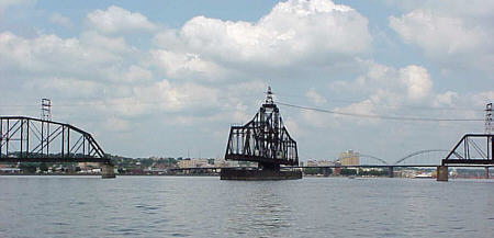 My only experience with the submerged bank protection lines had
come about 3 years earlier. We were boating in the Winfield area
in my 19’ Bayliner and I decided to explore one of these sloughs.
After running aground at 25 MPH in the middle of a quarter mile wide channel
(that’s a whole another story) I decided to exit the area and get back on
the main channel. As we made or way out at idle speed the sickening
sound of aluminum kissing rock got everyone’s attention. I hadn’t been
watching the chart and sure enough it showed a “submerged bank protection”
line crossing our path. Because of the slow speed it didn’t damage
the lower unit but did a job on the prop.
My only experience with the submerged bank protection lines had
come about 3 years earlier. We were boating in the Winfield area
in my 19’ Bayliner and I decided to explore one of these sloughs.
After running aground at 25 MPH in the middle of a quarter mile wide channel
(that’s a whole another story) I decided to exit the area and get back on
the main channel. As we made or way out at idle speed the sickening
sound of aluminum kissing rock got everyone’s attention. I hadn’t been
watching the chart and sure enough it showed a “submerged bank protection”
line crossing our path. Because of the slow speed it didn’t damage
the lower unit but did a job on the prop.(Photo is one of the several swingbridges along this section of the Mississippi.) |