|
Mississippi River
Alton, IL to Clinton, IA 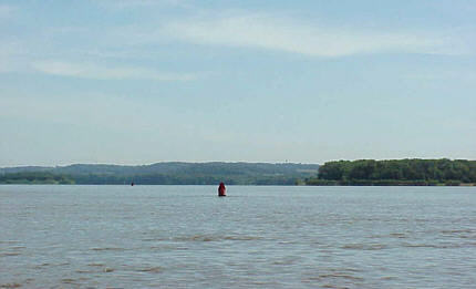 Here we go again! It 3:30 in the
morning. My deep sleep that had been annoyed off and on by
distant thunder is suddenly terminated by the sharp explosive blast
that must have originated very close by. I quickly scramble
out of the berth into the pilothouse to have a look at the
situation. Although there is no rain and little wind,
lightning is coming down from all directions in menacing pitchfork
shapes. Here we go again! It 3:30 in the
morning. My deep sleep that had been annoyed off and on by
distant thunder is suddenly terminated by the sharp explosive blast
that must have originated very close by. I quickly scramble
out of the berth into the pilothouse to have a look at the
situation. Although there is no rain and little wind,
lightning is coming down from all directions in menacing pitchfork
shapes.Appraising my situation, the anchorage that was a little questionable at dusk is now looking down right dumb. But I am getting ahead of myself. This is my third and last night on the water and trip has been excellent until this point so lets start at the beginning. I am once again out to explore new water and this trip is kind of a milestone. I am celebrating Therapy’s second birthday. It was this time in July two years ago she was launched on her maiden voyage. I have chosen to push north on the Mississippi River. At this point I have sailed the Upper Mississippi from the “0” mile marker At Cairo, IL to the 241 MM at Lock 25 near Winfield MO but it is time to continue on north. The temperatures in So. Illinois have been in the mid 90’s for days but a 3-day cool off was foretast so I decided to take advantage of it. I wanted a little cooler weather because I knew there was a good chance I would be spending a lot of time sitting. The problem is locks - MANY locks! From St. Louis south there is none but going north is a different story. In fact, the locks are closely spaced averaging only about 26 miles apart. That means for almost every hour of cruising time I will hit a lock. This makes planning an upriver trip a little difficult. I usually like to pick a destination and then estimate the time and fuel needed to reach it. This way I can give my wife an idea of how long she will have to man the office by herself. (Her view - how long she can “enjoy” being by herself) But obviously this won’t work on this trip. With this many locks there is no way I can estimate my time. It may take 30 minutes to get through one or it may take hours – there is no way to know until you get there. I decide to just keep it simple and go for a four day run. I will head north for two days and however far I get - that’s it. I will spend the night and then turn around and head back for the trailer. So that’s the plan – four days on the Upper Mississippi. 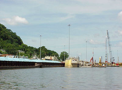 I trailer Therapy to Alton, IL at MM 202 and
drop in at the marina. I could have gotten about 16 miles
closed by using the Grafton, IL ramp but the last time I was there they
had removed the docks for some rework of the ramp area. I
didn’t know if they were back in place (I now know they are).
Since the current is fairly strong there I decided that Alton would be
a safer bet particularly since I was launching alone. Plus I
felt the area at the Alton Marina might be a little more active and
therefore might be in more secure setting for my truck and trailer to
sit. I trailer Therapy to Alton, IL at MM 202 and
drop in at the marina. I could have gotten about 16 miles
closed by using the Grafton, IL ramp but the last time I was there they
had removed the docks for some rework of the ramp area. I
didn’t know if they were back in place (I now know they are).
Since the current is fairly strong there I decided that Alton would be
a safer bet particularly since I was launching alone. Plus I
felt the area at the Alton Marina might be a little more active and
therefore might be in more secure setting for my truck and trailer to
sit.(Photo is of a tow working its way into Lock 24. It is located at Clarksville, MO and is undergoing a major overhaul.) I pulled away from the dock at 7:15 am and pointed the bow north into the current. The Alton Pool can be quite busy with pleasure boats at times but this early on a Tuesday I fairly well have the river to myself. The run to the first lock, Lock & Dam 25, is actually the one of the longest I will encounter on the trip. Forty five miles is the longest between locks but this is second at 37 miles. When I arrive at the lock and find a tow in the chamber. A call to the lockmaster yields a friendly reply but announces that I will have about an hour and a half wait. And so it begins…. I am not going into a blow-by-blow account of this trip. The truth is it would be rather boring as honestly there was nothing really extraordinary about. I am not saying that it was an unmemorable trip because I thoroughly enjoyed it. But still not the same experience, as say, the Tennessee River. Nonetheless I learned a lot. I encountered situations I had not experience before. And it is these I want to share with this story. Once again, I have both a Corps of Engineers river chart and Quimby’s Cruising Guide onboard. I feel both of there are essential. Yea, I know – “It’s a river – how do you get lost? Isn’t a chart a little overkill?” Well maybe. But it provides more than just the course of the waterway. Landmarks and mile markers allow you to know exactly where you are. This is important when calculating fuel stops. Although this section of the river is very well defined with channel markers the chart gives an idea of what is in the off channel areas. 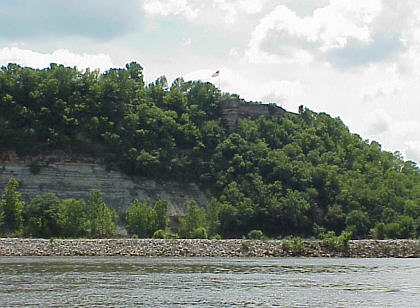 Quimby’s
also plays an important roll here. On this part of the
Mississippi fuel really is not a problem but still you need to know how
far it is until the next marina. Therapy performs better with
less fuel on board and using these tools I can push farther with lower
tanks. This improves both my speed and fuel economy. In
addition, Quimby’s will give me an idea of where there is food in
route. I usually like to try to catch a hot evening meal if possible. Quimby’s
also plays an important roll here. On this part of the
Mississippi fuel really is not a problem but still you need to know how
far it is until the next marina. Therapy performs better with
less fuel on board and using these tools I can push farther with lower
tanks. This improves both my speed and fuel economy. In
addition, Quimby’s will give me an idea of where there is food in
route. I usually like to try to catch a hot evening meal if possible.(Photo is of overlook near Hannibal, MO) I also have my trusty Magellan 330 GPS. This isn’t really a necessity but again handy to keep track of mileage and provides me true speed after the current adjust it. Again, this makes fuel usage projections more accurate. (Not to mention it is sort of a fun toy to play with along the way.) |