|
Page 3
The 57-mile run to Claiborne Lock, the last one on the Alabama, was uneventful. The scenery varied from quite enjoyable to boring but the anticipation of what’s around the next bend always seems to keep me occupied. At the lock I once again couldn’t get a radio response and resorted to the small craft signal. The lockmaster walked out on to the wall to say hi and we chatted a little before he ran me through. The drop this time was only about 15’ and I could tell that the water levels on the other side were a little elevated from normal.
Continuing on south it again appeared that the current had picked up a bit more. There was still 72 miles to cover before the Alabama deposits its load into the Tenn-Tom. The closer I came the higher the water levels appeared. This section of the river was not nearly as scenic as the upper Alabama. Shorelines were lower and lacked the interesting rock formations.
At the 10-mile marker (mile markers are scarce on the Alabama) I passed the only commercial traffic I had seen the entire 278 miles. A tow with a single barge loaded with two pieces of equipment was making its way upstream. There was a banner on the side of it but I did not understand its importance until later. I’ll explain on the return trip.
About 11:45 I was at the mouth of the Alabama River at the 45-mile marker of the Tenn-Tom. As I had expected the Tenn-Tom was running at fairly high water levels. Along with the high waters of spring also comes the winter’s deadwood washing out of all the creeks. Everything from branches to small trees would be accompanying me on my way to the gulf. In addition, commercial traffic was much more prevalent working the waters in both directions. As always I just give them a wide berth and pass by with no problems.
I make Mobile Harbor and am again awed by the shear size of some of the vessels. It is a busy place and I just try to stay out of the way as I move towards the bay. Just as I approach the end of the harbor my fuel tank runs dry and the Honda sputters to a stop. I make the change to the other tank (normal procedure) but just sit there a while taking it all in.
The shortest route to the protected Intracosatal waterway is about 33 miles to the southeast. I set the waypoint on the GPS and use it and a compass heading to direct Therapy towards the vacant horizon. I had wanted to make the Bay today as the wind forecast were the lowest for several days. Still the bay is shallow (11 ft was the deepest I found) and it takes just a little wind to cut it up. It is not bad today and with a little down trim tab I can ride comfortably at about 20 mph.
The crossing goes well and I continue on up Intracoastal Waterway. The first few miles are narrow and canal like with homes attractive homes and park on the south side and a few businesses on the other. It widens out into what appears like lakes as it wanders on its easterly course.
The day is fading in to evening and I decide it is time to make some decisions about gas and tonight’s accommodations. I am passing by a marina with a small restaurant and gas pump right on the water and decide to pull in for fuel for both Therapy and me (can’t remember the name!). As I refuel I ask about the menu and am told they are getting ready to close for the night but if I want a carryout they still can make it. Not knowing what’s ahead I decide that hot carryout is better then cold cuts so I place the order.
Quimby’s list a couple of marinas in the vicinity that has showers but none are on channel. Normally not a problem but they are describing their location by coves and passes and none of them are listed that way on my chart plotter. AND I don’t have a real chart! Normally I am a little anal about having the charts and maps on hand but since I couldn’t come to a decision about where I was going for this trip I didn’t have time to order them. Now darkness is approaching and I haven’t a clue where to go.
I continue on east hoping to find something. Nothing. Now its dark and no moon. Did I mention I hate running in the dark? But here it is a little different. Normally I worry about floating logs and rock dikes. I am a quarter mile from shore, 25’ of water and no one else around. I refer to Quimby’s again and find that Southwind Marina is about 3 miles away and on the channel. Plus they have a restaurant and showers. At cruise speed it should be less than 10 minutes. Let’s go.
|
 The
next morning I awoke to a cool berth but at 46 it was 10 degrees warmer
than yesterday. There was a little fog but very little and still no
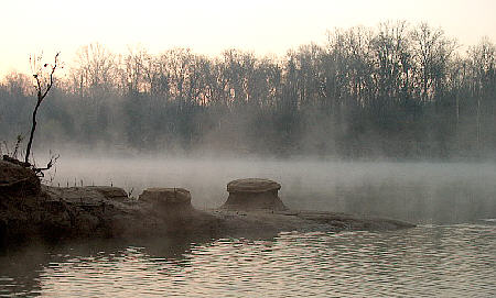
wind. I noticed some unusual rock formations at the creeks
mouth that I had missed in the dark. I drug up the two
anchors eased back on to the Alabama. I noted that the
current was definitely stronger on this side of the lock and was now
about 2 mph. I had only made 164 miles yesterday because of the time
lost at the lock so I was anxious to close the gap on Destin.
The
next morning I awoke to a cool berth but at 46 it was 10 degrees warmer
than yesterday. There was a little fog but very little and still no
wind. I noticed some unusual rock formations at the creeks
mouth that I had missed in the dark. I drug up the two
anchors eased back on to the Alabama. I noted that the
current was definitely stronger on this side of the lock and was now
about 2 mph. I had only made 164 miles yesterday because of the time
lost at the lock so I was anxious to close the gap on Destin.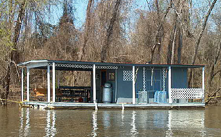 Also,
there were few cabins or homes but in their place I started to see a
few of what I called shanty boats. I don’t think that is the proper
term as I believe shanty boats are designed to actually move
from place to place. These cabins on floats were stationary
with no direct land access as they could only be
boarded from the water. Some were a little crude while others
were quite nice. A cabin on the river with no real estate tax
- interesting idea.
Also,
there were few cabins or homes but in their place I started to see a
few of what I called shanty boats. I don’t think that is the proper
term as I believe shanty boats are designed to actually move
from place to place. These cabins on floats were stationary
with no direct land access as they could only be
boarded from the water. Some were a little crude while others
were quite nice. A cabin on the river with no real estate tax
- interesting idea.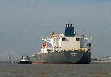 Although
I have crossed Mobile Bay once before I have to admit that the size of
it did give me slight pause – again. Even though the bay is
almost completely enclosed by the mainland on three sides and barrier
islands to the Gulf, it is still a large body of water to a puddle
jumping river rat like me. It is about 15 miles wide and 30
miles long. And there must be something in the water that
effects wooden boats because Therapy certainly seems to shrink when
sitting in the middle of it. And the farther out I go the
smaller it gets.
Although
I have crossed Mobile Bay once before I have to admit that the size of
it did give me slight pause – again. Even though the bay is
almost completely enclosed by the mainland on three sides and barrier
islands to the Gulf, it is still a large body of water to a puddle
jumping river rat like me. It is about 15 miles wide and 30
miles long. And there must be something in the water that
effects wooden boats because Therapy certainly seems to shrink when
sitting in the middle of it. And the farther out I go the
smaller it gets. 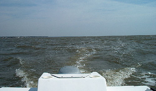 As
I am waiting for that I ask if they have space for Therapy for the
night. They do but it is on the open wall just 30 ft away
from the fuel pump. The wind is not strong but blowing enough it is
bouncing us off the wood dock. It wouldn’t make for a
pleasant night. I decide to eat my burger on the run and
check for different marina. Normally I like to anchor out but at this
point I am in sorry need of a shower. This is my third day without and
I am in serious need of a scrub & buff.
As
I am waiting for that I ask if they have space for Therapy for the
night. They do but it is on the open wall just 30 ft away
from the fuel pump. The wind is not strong but blowing enough it is
bouncing us off the wood dock. It wouldn’t make for a
pleasant night. I decide to eat my burger on the run and
check for different marina. Normally I like to anchor out but at this
point I am in sorry need of a shower. This is my third day without and
I am in serious need of a scrub & buff.