|
Page 2
From there the river immediately took on a rural appearance. In some areas there were an abundance of cabins and homes while in others there tree covered shorelines. The light fog was still present. I was watching my new chart plotter and was disappointed and curious with the lack of detail the GPS was showing. Something wasn't looking right.
I had traveled about 15 miles when I noticed that I was approaching and area where a couple of major creeks dumped in to the Alabama and had created several islands. Then suddenly the fog dropped like a curtain and visibility was next to nothing. Naturally as that occurred I somehow lost the river channel and the bottom alarm started yelping. I dropped off plane and found myself looking for not only the channel but also any break the wall of white that would help me locate myself on the river. The Alabama is not a wide river by any means so a turn to the starboard brought a misty view of the tree-lined bank with in a few moments.
After about 30 minutes of seeing nothing out of the windshield things finally started to lift. Now I could see that there were again cabins and homes along the banks and all were elevated on stilts. The air was motionless and the water like glass as I nursed Therapy back on plane and let her cruise at 24 MPH. There was a little current but only about 1 MPH so the GPS was showing a forward progress of about 25.
If finally dawned on me that the problem with the lack of visual information on the new chart plotter was simply operator error. In my haste to get underway this morning I forgot to swap the memory card with the detailed information for that area. I was running on the one I had set-up for the car trip to Montgomery not the one with the river info. I made the change and screen popped to life with a much more accurate representation of river ahead.
Fifty-two miles into the trip at mile marker 236 Robert Henry Lock came into view. With a call on channel 16 the lockmaster said the chamber was full and he would open the miter gates. Within minutes they silently eased about halfway open and stopped. There was no indicator lights, horn sound or call from the lockmaster so I went ahead and entered the lock and tied off on one of the floating pins. The water level started dropping immediately and in about 15 minutes I found myself 35’ lower than before. The downstream miter gates opened and again without a signal I castoff and departed the lock. The lockmaster was standing out along the rail and I waived thanks as I crossed the sill.
I continued my southward journey along the very winding path the centuries old river had carved through the stone. Some impressive bluffs with inventive names White Bluff and Red Bluff revealed hues that established their identity. The surface water was motionless but the current seemed to have picked up a little helping my decent to sea level. I had the river completely to myself and we were getting to know each other without distraction from commercial tows or bass boats with speeds approaching the sound barrier.
At about 1:30 pm and mile marker 136 I find myself at the Highway 28 bridge. On the other side I can see the Alabama’s second lock –Millers Ferry but I am looking for the channel that leads to the Sand Island Marina. Quimby’s states that the marina is about a half mile off the main river and above the bridge but I am not seeing it. The river is fairly wide at this point but looks shallow once out of the channel. I have to get there to refuel, as the next gas is about 170 miles down stream.
I top off the tank and head to the lock this time using the correct route. As I approach the lock I try channel 16 a couple of times but no response. I idle up to the short wall and pull the rope on the small craft signal but still no reply. I am looking around and spot a sign – Hours of Operation - 6AM to 2PM and 6PM to 2AM. I look at my watch – 2:20 PM……… Looks like I have a 3 1/2 hour wait!
I drag out the book and prop my feet up. River travel is many thing but fast isn’t one of them. About 4:30 I decide to go back to the marina for an evening meal. They have a grill there and a burger with homemade coleslaw goes down well.
I decided I wanted to go ahead and get through the lock tonight so not to be delayed in the morning. The only problem with this plan was that sunset was 5:56pm and The lock opens At 6 pm. By the time I lock through it will be dark and I detest running rivers in the dark! As I arrive the lockmaster is just coming on duty and feels sorry for me and goes ahead and locks me through 15 minutes before the start of his shift. By the time I finished the 39’ decent it is almost completely dark. Did I mention I really hate running rivers at night? The lockmaster offers to allow me to hang on the inside of the longwall for the night. He said there was no commercial traffic coming so it wouldn’t be a problem. But once out there I realized that they were dumping a lot of water over the dam and it was very rough at the wall. No way could I sleep there with Therapy banging up against it all night. So I thanked him for the offer and push off into the darkness.
The chart plotter indicated several creeks entering the river and I hoped one would yield a sheltered mooring for the night. The first two weren’t suitable but finally about five miles down I found Dixon Creek. It wasn’t big but with an anchor off the bow and one off stern to hold her in check Therapy would be safe for the night.
With all secure I finally noticed the coolness of the still night air. I looked above and the sky was clear with the stars dominating the heavens in vast numbers normally obscured by glow of civilization. But not here. The sights and sounds of the hectic everyday life were far away in a land from which I had escaped. Tonight there was just the stars, the silence and me. Then the cell phone rang…….. My wife just wanting to check to see how things were going. What the heck. Where’s the laptop. Time to watch a good movie where things get blown up!
|
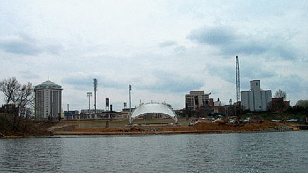 I passed Montgomery’s brief
downtown waterfront and noticed some new construction taking
place. It looked like a park. But the fog was
present and dampened the photo op. (Photo on right taken on
the return trip)
I passed Montgomery’s brief
downtown waterfront and noticed some new construction taking
place. It looked like a park. But the fog was
present and dampened the photo op. (Photo on right taken on
the return trip)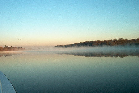 After
wandering back and forth across the river and around a small island I
finally found the 25’ deep channel. I plowed along off plane
keeping the almost invisible shoreline on my port side. I
actually wasn’t to concerned from a safety aspect as I understood that
the Alabama had almost no commercial traffic and I had seem no other
pleasure boat activity.
After
wandering back and forth across the river and around a small island I
finally found the 25’ deep channel. I plowed along off plane
keeping the almost invisible shoreline on my port side. I
actually wasn’t to concerned from a safety aspect as I understood that
the Alabama had almost no commercial traffic and I had seem no other
pleasure boat activity.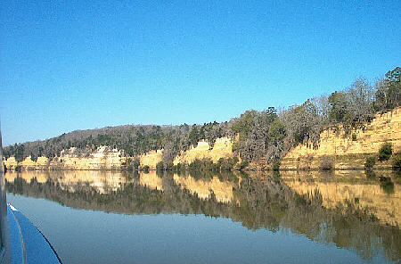 I
decide to venture off taking it slow towards where I think the marina
should be. Yea, its shallow at about 2 to 3 feet but I squeak
across. Once I get half way there I spot the small
white buoys that mark the zigzag course offering adequate
water. It exits off the main channel about a half-mile before
the bridge and I went past them without noticing. NO problem.
I make it to the 15’ of water of the old creek bed and proceed to the
gas pump. There I have a conversation with a gentleman living
aboard a houseboat moored to the dock. Said he had been there
since December. He was heading to Gulf Shores but hadn’t made
it yet. A tough life but somebody got to do it.
I
decide to venture off taking it slow towards where I think the marina
should be. Yea, its shallow at about 2 to 3 feet but I squeak
across. Once I get half way there I spot the small
white buoys that mark the zigzag course offering adequate
water. It exits off the main channel about a half-mile before
the bridge and I went past them without noticing. NO problem.
I make it to the 15’ of water of the old creek bed and proceed to the
gas pump. There I have a conversation with a gentleman living
aboard a houseboat moored to the dock. Said he had been there
since December. He was heading to Gulf Shores but hadn’t made
it yet. A tough life but somebody got to do it.