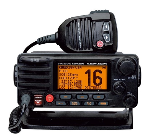
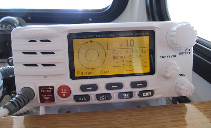
 Next was the new
marine
VHF radio with AIS capability (Automatic Identification System). My
radio is mounted on top of the instrument
panel so making this change was very simple and took just a few
minutes.
Because it was the same brand as my existing radio all the connectors
and plugs
mated so the electrical hookup was also easy. AIS is a very interesting
feature
and if you are buying a new radio I would certainly consider it -
especially if
you cruise in places that have commercial traffic. The extra cost are
reasonably small and the benefit large.
Plus no additional antenna is needed - the normal
VHF antenna serves a
dual purpose.
Next was the new
marine
VHF radio with AIS capability (Automatic Identification System). My
radio is mounted on top of the instrument
panel so making this change was very simple and took just a few
minutes.
Because it was the same brand as my existing radio all the connectors
and plugs
mated so the electrical hookup was also easy. AIS is a very interesting
feature
and if you are buying a new radio I would certainly consider it -
especially if
you cruise in places that have commercial traffic. The extra cost are
reasonably small and the benefit large.
Plus no additional antenna is needed - the normal
VHF antenna serves a
dual purpose.
 But it makes it even
easier. With the
press of a couple
buttons I can make a direct call to the other craft using the radio’s
DSC
(Digital Selective Calling). The radio in the other boat sounds an tone
like a “ring”
and they answer allowing two way communication. I don’t have to hail
them or
know their call name (although I do at that point).
But it makes it even
easier. With the
press of a couple
buttons I can make a direct call to the other craft using the radio’s
DSC
(Digital Selective Calling). The radio in the other boat sounds an tone
like a “ring”
and they answer allowing two way communication. I don’t have to hail
them or
know their call name (although I do at that point).
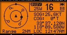
The top photo of the small screen on the radio itself with AIS targets showing. The AIS range on this radio is up to 10 miles and in this situation is is set to display up to 2NM. The dots indicate the location of the AIS boats relative to your location. The small line radiating from the dot points to the boats heading. The dots change from a circle to a black dot as you rotate through the list of available targets.
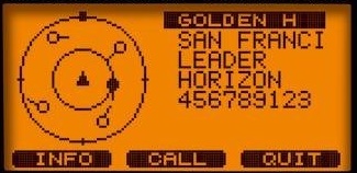
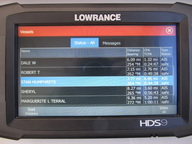
With the radio networked I can bring up this screen on the plotter. It list the names or the MMSi numbers of all the AIS vessels in the area. In this situation there are eight so I have to scroll through the screen to see them all. Although the radio is maxed at a 10 mile range the plotter will usually pickup anything with in 15 to 18 miles. On this screen I have selected the Stan Humphreys. Touching it brings up the screen below.
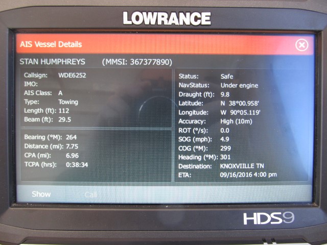
Here is the INFO screen showing the AIS info on the Stan Humphreys. The amount of data for the individual boat will vary but this one is fairly complete. This is a loaded (draught 9.8) river tow making 4.9 MPH on a heading of 301. The Length and Beam are shown (this is just the tug - not the load of barges). It is 7.75 miles away from me on a bearing of 264 degrees. The system tells me it's status is SAFE meaning there is no collision course at the present time. The CPA (Closest Point of Approach) shows if we both stay on our present course the closest we will come to one another is 6.96 miles in 38 minutes and 34 seconds (TCPA - Time To Closest Point Of Arrivial) I can set alarms for both CPA and TCPA and if it is calculated the boats will pass nearer than those limits the alarm be activated. For example, I can say as long as any approaching AIS vessels are more than a mile away or more than 3 minutes away thats OK but if it is calculated to pass closer let me know. This is a great safety feature.
At the bottom there is a "CALL" button which will start the direct radio call and the "SHOW" button which brings up the screen below.
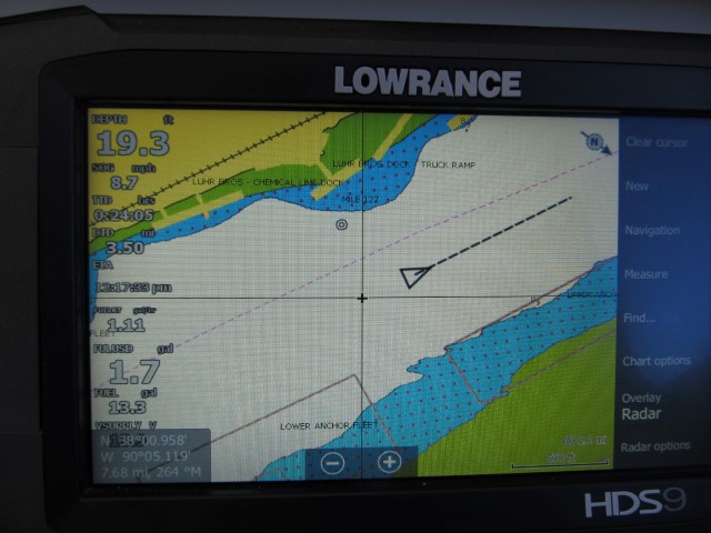
Above is how the icon of a vessel shows on the chart screen. It places it right on the chart so I have a very good idea of it's location. The line again shows its direction of travel. If it is dead in the water only the triangle will show - no line.
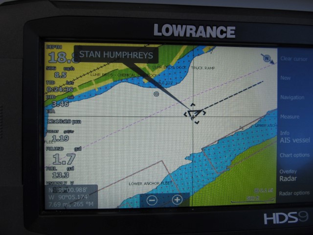
If I am just cruising and notice the triangle symbol on the chart, all I have to do is touch the triangle. A text box will appear showing the boats name or MMSI #. Touching the text box then brings up the INFO screen shown several photos above. It is just a quicker way to get to the boat's AIS data.
NOTE - Class A AIS transmits the craft's MMSI number and other critical location information every 2 to 10 seconds BUT the other data like the vessel's name, draught and size are only broadcast every 6 minutes. So you may have to wait a little to get all the available info. (see full list below)
List
of data transmitted by AIS
An AIS transceiver sends the following data every 2 to 10 seconds depending on a vessel's speed while underway, and every 3 minutes while a vessel is at anchor:
- The vessel's Maritime Mobile Service Identity (MMSI) – a unique nine digit identification number.
- Navigation status – "at anchor", "under way using engine(s)", "not under command", etc.
- Rate of turn – right or left, from 0 to 720 degrees per minute
- Speed over ground – 0.1-knot (0.19 km/h) resolution from 0 to 102 knots (189 km/h)
- Positional accuracy:
- Longitude – to 0.0001 minutes
- Latitude – to 0.0001 minutes
- Course over ground – relative to true north to 0.1°
- True heading – 0 to 359 degrees (for example from a gyro compass)
- True bearing at own position. 0 to 359 degrees
- UTC Seconds – The seconds field of the UTC time when these data were generated. A complete timestamp is not present.
In addition, the following data are broadcast every 6 minutes:
- IMO ship identification number – a seven digit number that remains unchanged upon transfer of the ship's registration to another country
- Radio call sign – international radio call sign, up to seven characters, assigned to the vessel by its country of registry
- Name – 20 characters to represent the name of the vessel
- Type of ship/cargo
- Dimensions of ship – to nearest meter
- Location of positioning system's (e.g., GPS) antenna on board the vessel - in meters aft of bow and meters port or starboard
- Type of positioning system – such as GPS, DGPS or LORAN-C.
- Draught of ship – 0.1 meter to 25.5 meters
- Destination – max. 20 characters
- ETA (estimated time of arrival) at destination – UTC month/date hour:minute
- optional : high precision time request, a vessel can request other vessels provide a high precision UTC time and datestamp